Kilmez (river)
Appearance
| Kilmez | |
|---|---|
 | |
 | |
| Native name | Кильмезь (Russian) |
| Location | |
| Country | Russia |
| Physical characteristics | |
| Mouth | Vyatka |
• coordinates | 56°57′20″N 50°28′06″E / 56.95556°N 50.46833°E |
| Length | 270 km (170 mi) |
| Basin size | 17,200 km2 (6,600 sq mi) |
| Basin features | |
| Progression | Vyatka→ Kama→ Volga→ Caspian Sea |
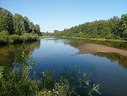
The Kilmez (Russian: Кильмезь; Udmurt: Калмез) is a river in Udmurtia and Kirov Oblast in Russia, a left tributary of the Vyatka. The river is 270 kilometres (170 mi) long, and the area of its drainage basin is 17,200 square kilometres (6,600 sq mi).[1] The Kilmez freezes up in November and remains icebound until the second half of April. Its main tributaries are the rivers Lumpun, Loban, and Vala.
References
- ^ «Река Кильмезь», Russian State Water Registry
