Wezup
Appearance
Wezup | |
|---|---|
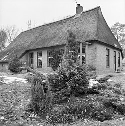
 Farm in Wezup | |
| Coordinates: 52°48′43″N 6°43′9″E / 52.81194°N 6.71917°E | |
| Country | Netherlands |
| Province | Drenthe |
| Municipality | Coevorden |
| Area | |
| • Total | 0.68 km2 (0.26 sq mi) |
| Elevation | 18 m (59 ft) |
| Population (2021)[1] | |
| • Total | 170 |
| • Density | 250/km2 (650/sq mi) |
| Time zone | UTC+1 (CET) |
| • Summer (DST) | UTC+2 (CEST) |
| Postal code | 7852[1] |
| Dialing code | 0591 |
| Website | wezup.info |
Wezup is a village in the Netherlands that is a part of the Coevorden municipality in Drenthe.[3] North of Wezup is Wezuperbrug and to the east is Zweeloo.
Wezup is an esdorp which was first mentioned in 1284 as Wesepe, and means "brook through the meadow".[4][5] In 1488, it became a boermarke, a communal and private land which was autonomous.[6] In 1840, it was home to 168 people.[5]
References
- ^ a b c "Kerncijfers wijken en buurten 2021". Central Bureau of Statistics. Retrieved 13 March 2022.
- ^ "Postcodetool for 7852PA". Actueel Hoogtebestand Nederland (in Dutch). Het Waterschapshuis. Retrieved 12 March 2022.
- ^ Guit, Hjalmar (August 28, 2021). "Coevorden trapt cultureel jaar af met bustour langs alle dorpen". www.rtvdrenthe.nl (in Dutch).
- ^ "Wezup - (geografische naam)". Etymologiebank (in Dutch). Retrieved 13 March 2022.
- ^ a b "Wezup". Plaatsengids (in Dutch). Retrieved 13 March 2022.
- ^ "Historie". Wezup.info (in Dutch). Retrieved 13 March 2022.
External links
 Media related to Wezup at Wikimedia Commons
- Official website (in Dutch)


