Beebo, Queensland
| Beebo Queensland | |||||||||||||||
|---|---|---|---|---|---|---|---|---|---|---|---|---|---|---|---|
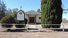
 St Paul's Lutheran Church, 2019 | |||||||||||||||
| Coordinates | 28°40′58″S 150°59′35″E / 28.6827°S 150.9930°E | ||||||||||||||
| Population | 84 (2016 census)[1] | ||||||||||||||
| • Density | 0.3611/km2 (0.935/sq mi) | ||||||||||||||
| Established | 1877 | ||||||||||||||
| Postcode(s) | 4385 | ||||||||||||||
| Area | 232.6 km2 (89.8 sq mi) | ||||||||||||||
| Time zone | AEST (UTC+10:00) | ||||||||||||||
| Location |
| ||||||||||||||
| LGA(s) | Goondiwindi Region | ||||||||||||||
| State electorate(s) | Southern Downs | ||||||||||||||
| Federal division(s) | Maranoa | ||||||||||||||
| |||||||||||||||
Beebo is a rural locality in the Goondiwindi Region, Queensland, Australia.[2] It is on the border between Queensland and New South Wales. In the 2016 census, Beebo had a population of 84 people.[1]
Geography
Beebo is bounded to the south-west by the Dumaresq River, the border between Queensland and New South Wales.[3]
Magee is a neighbourhood in the locality (28°40′00″S 151°03′00″E / 28.6666°S 151.05°E) around the now-abandoned Magee railway station on the former Texas branch railway line.[4][5]
The north-west of the locality is within the Yelarbon State Forest which extends into Glenarbon to the north and west and into Brush Creek to the north-east.[3]
History
Beebo was opened for selection on 17 April 1877; 21 square miles (54 km2) were available.[6]

The Beebo Provisional School opened on 4 November 1901 and became Beebo State School on 1 January 1909. The school closed on several occasions due to low student numbers, finally closing on 25 September 1964.[7] The school was on the Texas Yelarbon Road at 28°43′24″S 150°57′55″E / 28.7232°S 150.9654°E.[8]
The Texas branch railway line from Inglewood to Texas opened on 3 November 1930 with Beebo being served by the Magee railway station (28°40′06″S 151°03′05″E / 28.66829°S 151.05148°E).[9] The name Magee comes from Magee Creek, which was named after a stockman.[4][10]
Glenarbon Provisional School opened on 17 March 1933, becoming Glenarbon State School in 1940. It closed in 1982.[11] The school was located just to the south of the Texas Yelarbon Road at 28°41′01″S 150°53′28″E / 28.6835°S 150.8910°E within the present-day boundaries of Beebo.[12] The site is now a recreational reserve operated by the Goondiwindi Regional Council.[3]
St Paul's Lutheran Church was established circa December 1959.[13][14]
In the 2016 census, Beebo had a population of 84 people.[1]
Amenities
The former Glenarbon State School is now a recreational reserve operated by the Goondiwindi Regional Council.[3]
St Paul's Lutheran Church is on Glenarbon Church Road at 28°40′42″S 150°53′31″E / 28.6783°S 150.8919°E. It has a small cemetery.[3]
There is a public hall on the Texas Yelarbon Road (28°42′47″S 150°56′28″E / 28.7130°S 150.9410°E).[15]
Education
There are no schools in Beebo. The nearest primary schools are Inglewood State School in Inglewood to the north, Texas State School in Texas to the south-east, and Yelarbon State School in Yelarbon to the west. The nearest secondary schools are Inglewood State School (to Year 10) in Inglewood and Texas State School (for Year 10) in Texas. For nearest school with secondary schooling to Year 12 is Goondiwindi State High School in Goondiwindi to the west, but it is so distant that other options would be distance education or boarding school.[3]
References
- ^ a b c Australian Bureau of Statistics (27 June 2017). "Beebo (SSC)". 2016 Census QuickStats. Retrieved 20 October 2018.
- ^ "Beebo – locality in Goondiwindi Region (entry 47795)". Queensland Place Names. Queensland Government. Retrieved 6 May 2020.
- ^ a b c d e f "Queensland Globe". State of Queensland. Retrieved 18 October 2020.
- ^ a b "Magee – locality unbounded in Goondiwindi Regional (entry 20530)". Queensland Place Names. Queensland Government. Retrieved 23 October 2020.
- ^ "Railway stations and sidings - Queensland". Queensland Open Data. Queensland Government. 27 August 2020. Archived from the original on 5 October 2020. Retrieved 5 October 2020.
- ^ "Proclamations under the New Land Acts". The Brisbane Courier. Queensland, Australia. 2 March 1877. p. 3. Archived from the original on 27 August 2020. Retrieved 19 February 2020 – via Trove.
- ^ Queensland Family History Society (2010), Queensland schools past and present (Version 1.01 ed.), Queensland Family History Society, ISBN 978-1-921171-26-0
- ^ "Parish of Beebo" (Map). Queensland Government. 1929. Archived from the original on 30 August 2020. Retrieved 30 August 2020.
- ^ Kerr, John (1990). Triumph of narrow gauge : a history of Queensland Railways. Boolarong Publications. p. 136-137, 225. ISBN 978-0-86439-102-5.
- ^ "Magee Creek – watercourse in the Goondiwindi Region (entry 20531)". Queensland Place Names. Queensland Government. Retrieved 24 October 2020.
- ^ Queensland Family History Society (2010), Queensland schools past and present (Version 1.01 ed.), Queensland Family History Society, ISBN 978-1-921171-26-0
- ^ "Parish of Beebo" (Map). Queensland Government. 1929. Archived from the original on 30 August 2020. Retrieved 30 August 2020.
- ^ "LUTHERAN CONVENTION OPENS AT KALBAR". Queensland Times. No. 19, 752. Queensland, Australia. 24 April 1950. p. 2 (DAILY). Archived from the original on 30 August 2020. Retrieved 30 August 2020 – via National Library of Australia.
- ^ "Glenarbon's 60th Anniversary of Church Building Service". Qld District. Lutheran Church of Australia. 25 November 2019. Archived from the original on 30 August 2020. Retrieved 30 August 2020.
- ^ "Community facilities - Queensland". Queensland Open Data. Queensland Government. 22 October 2020. Archived from the original on 23 October 2020. Retrieved 23 October 2020.
Further reading
- Boddington, Ester; Donges, J.; Texas Historical Society (1995), The settlements of Glenarbon and Eldorado as I remember them c. 1932 & Short history of the border area of Queensland covered by the Glenarbon Beebo Branch of the Queensland Country Women's Association, Texas Historical Society
External links
![]() Media related to Beebo, Queensland at Wikimedia Commons
Media related to Beebo, Queensland at Wikimedia Commons

