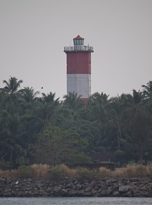
Beypore Lighthouse
Appearance
 View from the northern shore of Chaliyar | |
 | |
| Location | Feroke, Kerala |
|---|---|
| Coordinates | 11°09.4962′N 75°48.351′E / 11.1582700°N 75.805850°E |
| Tower | |
| Construction | concrete tower |
| Height | 30.48 metres (100.0 ft) |
| Shape | hexagonal tower with balcony and lantern |
| Power source | mains electricity |
| Racon | G[1] |
| Light | |
| First lit | 1977 |
| Focal height | 32 metres (105 ft) |
| Range | 16 nautical miles (30 km; 18 mi) |
| Characteristic | Fl (2) W 15s. |
The Beypore Lighthouse is a lighthouse at Feroke, Kozhikode, on the south shore of the Chaliyam River.[2][3] The six-sided tower has a height of 30.48 metres (100.0 ft). The tower is painted with red and white bands. The lighthouse started functioning on 21 November 1977. The light source is metal halide lamp.
See also
References
- ^ Beypore lighthouse Archived 11 March 2016 at the Wayback Machine Directorate General of Lighthouses and Lightshps
- ^ Rowlett, Russ. "Lighthouses of India: Kerala and Karnataka". The Lighthouse Directory. University of North Carolina at Chapel Hill. Retrieved 5 February 2016.
- ^ "Directorate General of Lighthouses and Lightships". Archived from the original on 12 March 2013. Retrieved 19 September 2014.
External links
- Beypore Lighthouse in Lighthouse Digest's Lighthouse Explorer Database

