
Huttange
Huttange
Hitten | |
|---|---|
 View over Huttange | |
| Country | |
| Canton | Redange |
| Commune | Beckerich |
| Population | |
| • Total | 29 |
| Time zone | UTC+1 (CET) |
| • Summer (DST) | UTC+2 (CEST) |
Huttange (Luxembourgish: Hitten) is a village in northwestern Luxembourg.[1]
It is situated in the commune of Beckerich and has a population of 29.[2]
Gallery
-
 Chapel of Huttange
 -
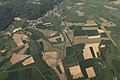 Aerial view of Beckerich and Huttange


References
- ^ "Geoportail". map.geoportail.lu. Retrieved 2022-05-24.
- ^ "Statistiques - Luxembourg". statistiques.public.lu (in French). Retrieved 2022-05-24.
49°44′09″N 5°53′51″E / 49.73583°N 5.89750°E
This article related to the geography of Redange canton is a stub. You can help Wikipedia by expanding it. |