Rom (river)
Appearance
| Rom | |
|---|---|
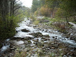
 Rom near Valchava, Val Müstair | |
 | |
| Location | |
| Country | Switzerland, Italy |
| Physical characteristics | |
| Mouth | Adige |
• coordinates | 46°40′14″N 10°32′40″E / 46.6705°N 10.5445°E |
| Length | 24.7 km (15.3 mi) |
| Basin size | 189 km2 (73 sq mi) |
| Basin features | |
| Progression | Adige→ Adriatic Sea |
The Rom (Romansh: Rom; Italian: Ram; German: Rombach in Switzerland or Rambach in South Tyrol (Italy) is a river in Switzerland and Italy. The 24.7-kilometre (15.3 mi) long river is a tributary of the Adige. It rises in the Ortler Alps, close to the Fuorn Pass. It flows through the Val Müstair in Switzerland, and joins the Adige near the town Glurns in the Italian province of South Tyrol. The drainage basin is 189 square kilometres (73 sq mi).
External links
 Media related to Rom at Wikimedia Commons
- Hydrological data of Rom at Müstair - real time and historical data: waterlevel, discharge, temperature
- Rio Ram: Descrizione geomorfologica (in Italian)
- Rambach: Geomorphologische Beschreibung (in German)
- Rom in Romansh in the online Lexicon Istoric Retic.
