
Mrákotín (Chrudim District)
Mrákotín | |
|---|---|
 Centre of Mrákotín | |
_vlajka.jpg) Flag _znak.jpg) Coat of arms | |
 Mrákotín Location in the Czech Republic | |
| Coordinates: 49°48′53″N 15°57′24″E / 49.81472°N 15.95667°E | |
| Country | |
| Region | Pardubice |
| District | Chrudim |
| First mentioned | 1456 |
| Area | |
| • Total | 5.18 km2 (2.00 sq mi) |
| Elevation | 453 m (1,486 ft) |
| Population (2023-01-01)[1] | |
| • Total | 333 |
| • Density | 64/km2 (170/sq mi) |
| Time zone | UTC+1 (CET) |
| • Summer (DST) | UTC+2 (CEST) |
| Postal code | 539 01 |
| Website | www |
Mrákotín is a municipality and village in Chrudim District in the Pardubice Region of the Czech Republic. It has about 300 inhabitants.
It is located about 28 kilometres (17 mi) southeast of Pardubice and 112 km (70 mi) east of Prague.
Administrative parts
The village of Oflenda is an administrative part of Mrákotín.
History
The first written mention of Mrákotín is from 1456.[2]
Gallery
-
 Municipal office
 -
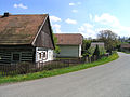 Northern part
 -
 World War I memorial


References
- ^ "Population of Municipalities – 1 January 2023". Czech Statistical Office. 2023-05-23.
- ^ "Historie" (in Czech). Obec Mrákotín. Retrieved 2022-07-18.
External links
Wikimedia Commons has media related to Mrákotín (Chrudim District).
| Authority control databases: National |
|---|
This Pardubice Region location article is a stub. You can help Wikipedia by expanding it. |