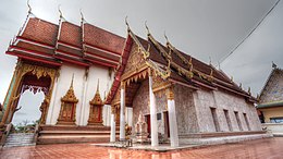
Bang Yai subdistrict, Nonthaburi
Appearance
Bang Yai Subdistrict
ตำบลบางใหญ่ | |
|---|---|
 Wat Anek Dittharam, one of the two Buddhist temples in the subdistrict | |
 | |
| Country | |
| Province | Nonthaburi |
| District | Bang Yai |
| Population | |
| • Total | 20,616 |
| Time zone | UTC+7 (ICT) |
| Postal code | 11140 |
| TIS 1099 | 120305 |
Bang Yai (Thai: บางใหญ่, pronounced [bāːŋ jàj]) is one of the six subdistricts (tambon) of Bang Yai District, in Nonthaburi Province, Thailand. The subdistrict is bounded by (clockwise from north) Ban Mai, Bang Mae Nang, Bang Muang, Sala Klang and Sala Ya subdistricts. In 2020, it had a total population of 20,616 people.[1][2]
Administration
Central administration
The subdistrict is subdivided into 6 administrative villages (muban).[3]
| No. | Name | Thai |
|---|---|---|
| 1. | Ban Bang Sano | บ้านบางโสน |
| 2. | Ban Khlong Bang Yai | บ้านคลองบางใหญ่ |
| 3. | Ban Chao (Ban Bang Yai) | บ้านเจ้า (บ้านบางใหญ่) |
| 4. | Ban Talat Bang Khu Lat | บ้านตลาดบางคูลัด |
| 5. | Ban Bang Yai | บ้านบางใหญ่ |
| 6. | Ban Si Yaek Khlong Yong | บ้านสี่แยกคลองโยง |
Local administration
The area of the subdistrict is shared by two local administrative organizations.
- Bang Yai Subdistrict Municipality (เทศบาลตำบลบางใหญ่)
- Bang Yai Subdistrict Administrative Organization (องค์การบริหารส่วนตำบลบางใหญ่)
References
- ^ a b "Population statistics 2020: Bang Yai District" (in Thai). Department of Provincial Administration. Retrieved 1 December 2021.
- ^ a b "Population statistics 2020: Bang Yai Subdistrict Municipality" (in Thai). Department of Provincial Administration. Retrieved 1 December 2021.
- ^ ประกาศกระทรวงมหาดไทย เรื่อง การกำหนดเขตตำบลในท้องที่อำเภอบางใหญ่ จังหวัดนนทบุรี (PDF). Royal Gazette (in Thai). 115 (special 34D): 128–153. 6 May 1998. Archived from the original (PDF) on November 14, 2011.
External links
- Website of Bang Yai Subdistrict Municipality
- Website of Bang Yai Subdistrict Administrative Organization
