Half Hollow Hills, New York
Half Hollow Hills, New York | |
|---|---|
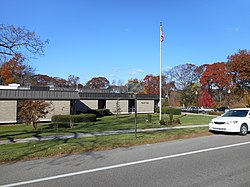
 The Half Hollow Hills Public Library in 2014. | |
| Country | |
| State | |
| County | Suffolk |
| Town | Babylon Huntington |
| Time zone | UTC−5 (Eastern (EST)) |
| • Summer (DST) | UTC−4 (EDT) |
| Area code(s) | 631,934 |
Half Hollow Hills is a large hamlet in the Towns of Babylon and Huntington in Suffolk County, Long Island, New York, United States.
Although the area is now frequently associated with portions of Deer Park, Dix Hills, Melville, South Huntington, Wheatley Heights, and Wyandanch, it remains a widely used place-name, which is still used by multiple special taxation districts in the area, including the Half Hollow Hills Central School District and the Half Hollow Hills Community Library District.
There have been multiple proposals made over the years to incorporate the area as the Incorporated Village of Half Hollow Hills.
History
Over the years, multiple attempts to incorporate Half Hollow Hills as a village have been made – most notably in the 1950s and in the early 2000s.[1][2][3] The boundaries of the large, proposed village would be coterminous with those of the Half Hollow Hills Central School District's boundaries and those of the Half Hollow Hills Community Library District's.
The reasons frequently cited for the proposals to incorporate are related to planning and zoning laws, as well as home rule.[1][2][3] During every major incorporation proposal made (i.e.: in 1955 and 2003), it had been felt by many in the community that the Towns of Huntington and Babylon were lax in their stances on new developments being constructed in the area, thus allowing the area to become more urbanized.[1][2][3]
Demographics
| Census | Pop. | Note | %± |
|---|---|---|---|
| 1960 | 2,171 | — | |
| 1970 | 12,181 | 461.1% | |
| U.S. Decennial Census[4] | |||
As of the 1970 United States census, the population of the hamlet was 12,181; the totals would be included with those of the Dix Hills CDP's beginning with the 1980 census.[5]
Education
School district
Half Hollow Hills is located entirely within (and is thus served by) the Half Hollow Hills Central School District.[1][6]
Library district
The hamlet is located entirely within (and is thus served by) the Half Hollow Hills Community Library District.[1][6]
Transportation
The Long Island Motor Parkway passed through the hamlet; portions of this highway survive as a Suffolk County-maintained thoroughfare through the area: County Route 67.[7][8]
See also
References
- ^ a b c d e "Talks on Proposed Village Due". The New York Times. February 13, 1955. ISSN 0362-4331. Retrieved July 10, 2021.
- ^ a b c "HUGE NEW VILLAGE ASKED IN SUFFOLK; It Would Take in 50 Square Miles in Huntington and Babylon Townships". The New York Times. February 6, 1955. ISSN 0362-4331. Retrieved July 10, 2021.
- ^ a b c Kutt Nahas, Donna (July 27, 2003). "Villages, Inc.: Hamlets Across the Island Weigh the Cost-Benefit Ratio of Incorporation". The New York Times. pp. 1, 11 – via ProQuest.
- ^ "Census of Population and Housing". Census.gov. Retrieved June 4, 2015.
- ^ Historical Population of Long Island Communities: 1790-1980 (PDF). Long Island Regional Planning Board. 1982.
- ^ a b "Long Island Index: Interactive Map". www.longislandindexmaps.org. Retrieved June 5, 2022.
- ^ Kahn, David (October 24, 1958). "Vanderbilt Motor Pkwy. Paved Way for Todays Highways: The Road That Made History Last of Two Parts". Newsday. pp. 1C – via ProQuest.
- ^ "New York State Department of Transportation Region 3 Inventory Listing". March 2, 2009 [March 2, 2009]. Archived from the original on April 19, 2014. Retrieved June 5, 2022.
