Danyang County
Danyang
단양군 | |
|---|---|
| Korean transcription(s) | |
| • Hangul | 단양군 |
| • Hanja | 丹陽郡 |
| • Revised Romanization | Danyang-gun |
| • McCune-Reischauer | Tanyang-gun |
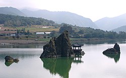
 Dodam Sambong | |
 Location in South Korea | |
| Country | |
| Region | Hoseo |
| Administrative divisions | 2 eup, 6 myeon |
| Area | |
• Total | 781.07 km2 (301.57 sq mi) |
| Population (2002) | |
• Total | 37,320 |
| • Density | 51/km2 (130/sq mi) |
| • Dialect | Chungcheong |
Danyang County (Danyang-gun) is in North Chungcheong Province, South Korea.
Symbols
- County tree: Yew tree
- County bird: Magpie
- County flower: Royal Azalea
Geography
The geographical terrain is 83.7% mountainous and 11.2% cultivable. It is very rugged, except in some of the urban areas and villages that can be found in the valleys and hills. The main water system ranges from the upper stream of the 23.7 km (14.7 mi) long Namhan River, which flows through the county. Pyeongchang River, one of the streams flowing from Odaesan, joins several streams at Jungnyeong, Danyang, and Geumgok, originating from Sobaeksan. Danyang Stream, which has its source in Hakseongsan, Gyeongsangbuk-do, joins the Namhan River at Habang-ri, Danseong-myeon, together with Jungnyeong Stream flowing from Jungnyeong and Dosolsan to Hyeoncholli, Danyang-eup, Maepo Stream from Geumsusan to Dodam, and Geumgok Stream from Biro Peak to Gosu-ri, Danyang-eup.[1]
Climate
Danyang has a monsoon-influenced humid continental climate (Köppen: Dwa) with cold, dry winters and hot, rainy summers. The county, which is situated in an inland mountainous area, epitomizes an inland climate with severe variations in temperatures. The annual average temperature reaches 11.7 °C (53.1 °F), with the highest at 17.9 °C (64.2 °F) and the lowest at 6.6 °C (43.9 °F), and its annual rainfall averages 1,049.9 mm (41.3 in).
| Climate data for Danyang (1993–2020 normals) | |||||||||||||
|---|---|---|---|---|---|---|---|---|---|---|---|---|---|
| Month | Jan | Feb | Mar | Apr | May | Jun | Jul | Aug | Sep | Oct | Nov | Dec | Year |
| Mean daily maximum °C (°F) | 2.2 (36.0) |
5.7 (42.3) |
11.9 (53.4) |
19.1 (66.4) |
24.9 (76.8) |
28.6 (83.5) |
29.8 (85.6) |
30.5 (86.9) |
25.9 (78.6) |
20.1 (68.2) |
11.8 (53.2) |
4.0 (39.2) |
17.9 (64.2) |
| Daily mean °C (°F) | −3.4 (25.9) |
−0.5 (31.1) |
5.2 (41.4) |
12.0 (53.6) |
17.7 (63.9) |
22.1 (71.8) |
24.7 (76.5) |
25.0 (77.0) |
19.6 (67.3) |
13.0 (55.4) |
5.9 (42.6) |
−1.4 (29.5) |
11.7 (53.1) |
| Mean daily minimum °C (°F) | −8.3 (17.1) |
−5.8 (21.6) |
−0.6 (30.9) |
5.5 (41.9) |
11.2 (52.2) |
16.7 (62.1) |
20.9 (69.6) |
21.1 (70.0) |
15.5 (59.9) |
8.2 (46.8) |
1.0 (33.8) |
−6.1 (21.0) |
6.6 (43.9) |
| Average precipitation mm (inches) | 14.9 (0.59) |
22.3 (0.88) |
38.4 (1.51) |
61.6 (2.43) |
69.9 (2.75) |
124.3 (4.89) |
253.2 (9.97) |
237.7 (9.36) |
126.5 (4.98) |
48.8 (1.92) |
34.7 (1.37) |
17.6 (0.69) |
1,049.9 (41.33) |
| Average precipitation days (≥ 0.1 mm) | 4.8 | 4.6 | 7.1 | 7.7 | 7.7 | 8.6 | 14.3 | 13.5 | 9.0 | 5.1 | 7.1 | 5.1 | 94.6 |
| Source: Korea Meteorological Administration[2] | |||||||||||||
Tourism
Twin towns – sister cities
Danyang is twinned with:
Domestic
- Songpa-gu, Seoul
- Eunpyeong-gu, Seoul
- Jung-gu, Busan
- Gyeyang-gu, Incheon
- Boryeong, South Chungcheong
- Icheon, Gyeonggi
- Guri, Gyeonggi
International
 Antu County, Jilin, China
 Danyang, Jiangsu, China
Gallery
-
Danyang Bridge
-
Danyang Bridge
-
Lookout above the riverfront
-
Waterfalls along the riverfront
-
Danyang city park
-
Danyang city park
-
Danyang Korail Train station
-
Tourist hotel typical of those along the riverfront
References
- ^ Official page of Danyang county http://english.dy21.net/english/
- ^ "Climatological Normals of Korea (1991 ~ 2020)" (PDF) (in Korean). Korea Meteorological Administration. Archived from the original (PDF) on 29 January 2022. Retrieved 7 June 2023.


