Jump to content

Nabaa Al Safa

Coordinates: 33°44′59″N 35°41′55″E / 33.74972°N 35.69861°E / 33.74972; 35.69861
From Wikipedia, the free encyclopedia

This is an old revision of this page, as edited by 213.204.77.130 (talk) at 21:43, 6 August 2023 (Fixed district of the village). The present address (URL) is a permanent link to this revision, which may differ significantly from the current revision.

Nabaa Al Safa
نبع الصفا
City
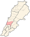
Map showing the location of Souk El Gharb within Lebanon
Nabaa Al Safa
Location within Lebanon
Coordinates: 33°44′59″N 35°41′55″E / 33.74972°N 35.69861°E / 33.74972; 35.69861
Country Lebanon
GovernorateMount Lebanon Governorate
DistrictAley District
Time zoneUTC+2 (EET)
 • Summer (DST)UTC+3 (EEST)
Dialing code+961

Nabaa Al Safa (Arabic: نبع الصفا), is a village in Chouf District in the Mount Lebanon Governorate of Lebanon.