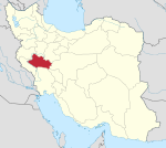
Bazvand Rural District
Appearance
Bazvand Rural District
| |
|---|---|
| Coordinates: 33°16′10″N 47°35′16″E / 33.26944°N 47.58778°E[1] | |
| Country | |
| Province | Lorestan |
| County | Rumeshkan |
| District | Central |
| Population (2016)[2] | |
• Total | 8,114 |
| Time zone | UTC+3:30 (IRST) |
Bazvand Rural District (Template:Lang-fa) is in the Central District of Rumeshkan County, Lorestan province, Iran.
At the most recent census of 2016, the population of the rural district was 8,114 in 2,327 households. The largest of its six villages was Khirdarar, with 1,757 people.[2]
History
There is a Bronze Age mound in the district, that is registered as a national monument.[3]
Economy
The area is primarily agricultural, with herding and cereal crops. Water is from wells. The villagers also produce handicrafts which bring in additional income.[4]
Villages
The rural district has eight villages:
References
- ^ OpenStreetMap contributors (28 August 2023). "Bazvand Rural District (Rumeshkan County)" (Map). OpenStreetMap. Retrieved 28 August 2023.
- ^ a b "Census of the Islamic Republic of Iran, 1395 (2016)". AMAR (in Persian). The Statistical Center of Iran. p. 15. Archived from the original (Excel) on 12 October 2020. Retrieved 19 December 2022.
- ^ National monument registration number 17182. "تپه عمولان بازوندی". Encyclopaedia of the Iranian Architectural History. Cultural Heritage and Tourism Organization of Iran.
- ^ "بازوندی" [Bazvandi]. Dehkhoda Dictionary (in Persian). Archived from the original on 1 October 2015.


