
Sady Dolne
Sady Dolne | |
|---|---|
Village | |
.jpg) A house | |
 Sady Dolne Location of Sady Dolne | |
| Coordinates: 50°54′00″N 16°11′00″E / 50.90000°N 16.18333°E | |
| Country | |
| Voivodeship | Lower Silesian |
| Powiat | Jawor |
| Gmina | Bolków |
| Population | 391 |
Sady Dolne [ˈsadɨ ˈdɔlnɛ] is a village in the administrative district of Gmina Bolków, within Jawor County, Lower Silesian Voivodeship, in south-western Poland.[1]
It lies approximately 7 km (4 mi) south-east of Bolków, 17 km (11 mi) south of Jawor, and 65 km (40 mi) south-west of the regional capital Wrocław.
Gallery
-
 Local chateaux
 -
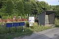 Bus stop shelter
 -
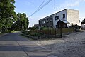 Newer house
 -
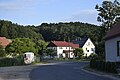 Road
Road -
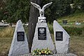 WWII memorial
.JPG)
.jpg)
.jpg)
.jpg)
.jpg)
References
Wikimedia Commons has media related to Sady Dolne.
| Town and seat |  | |
|---|---|---|
| Villages | ||
This Jawor County location article is a stub. You can help Wikipedia by expanding it. |