Lindong
Lindong
林东镇 • ᠯᠢᠨᠳᠦ᠋ᠩ ᠪᠠᠯᠭᠠᠰᠤ | |
|---|---|
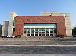
 Liao Shangjing Museum | |
| Coordinates (Lindong town government): 43°58′05″N 119°22′32″E / 43.9681°N 119.3756°E | |
| Country | People's Republic of China |
| Autonomous region | Inner Mongolia |
| Prefecture-level city | Chifeng |
| Banner | Bairin Left Banner |
| Population (2018)[1] | |
| • Total | 68,000 |
| Time zone | UTC+8 (China Standard) |
Lindong (simplified Chinese: 林东镇; traditional Chinese: 林東鎮; pinyin: Líndōng Zhèn, Mongolian:ᠯᠢᠨᠳᠦ᠋ᠩ ᠪᠠᠯᠭᠠᠰᠤ)[2][3] is a town in the Balin Left Banner, Chifeng, within the Inner Mongolia Autonomous Region of the People's Republic of China.[4][2] The town has an area of 881 square kilometres (340 sq mi), and a population of 68,000, according to a 2020 publication by the Balin Left Banner government.[5] The town serves as the administrative seat of the Balin Left Banner.[5][6]
Geography
[edit]Lindong lies adjacent to Balin Left Banner's urban core.[5] Large swathes of the town are forests and grasslands.[5]
Climate
[edit]The town has a continental climate, experiencing an average of 3,000 hours of sunshine annually, 166.4 millimetres (6.55 in) to 366.4 millimetres (14.43 in) of precipitation annually, and 120 to 130 frost-free days annually.[5]
Administrative divisions
[edit]Lindong is divided into 33 administrative villages (Chinese: 行政村; pinyin: xíngzhèng cūn).[5][7] The town also hosts 125 natural villages (Chinese: 自然村; pinyin: zìrán cūn),[5] which lack jurisdictional authority, and belong to the town's administrative villages. The towns administrative villages are as follows:[7]
- Suobuliga Village (Chinese: 索布力嘎村)
- Fushandi Village (Chinese: 福山地村)
- Daxinzhuang Village (Chinese: 大新庄村)
- Xinglongdi Village (Chinese: 兴隆地村)
- Chaoyangyingzi Village (Chinese: 朝阳营子村)
- Chaidamu Village (Chinese: 柴达木村)
- Hantubai Village (Chinese: 罕吐柏村)
- Taiping Village (Chinese: 太平村)
- Panlonggang Village (Chinese: 蟠龙岗村)
- Shanwan Village (Chinese: 山湾村)
- Baolihantu Village (Chinese: 宝力罕吐村)
- Bayi Village (Chinese: 八一村)
- Xianfeng Village (Chinese: 先锋村)
- Hongweizhuang Village (Chinese: 红卫庄村)
- Jingzigou Village (Chinese: 井子沟村)
- Tulonggang Village (Chinese: 土龙岗村)
- Houxinglongdi Village (Chinese: 后兴隆地村)
- Longfenggou Village (Chinese: 龙凤沟村)
- Xinfangshen Village (Chinese: 新房身村)
- Gushanzi Village (Chinese: 孤山子村)
- Dongxinjing Village (Chinese: 东新井村)
- Yamenmiao Village (Chinese: 衙门庙村)
- Suobeishan Village (Chinese: 索贝山村)
- Shuiquangou Village (Chinese: 水泉沟村)
- Shisanhao Village (Chinese: 十三号村)
- Beijing Village (Chinese: 北井村)
- Mantou'aobao Village (Chinese: 馒头敖包村)
- Fushan Village (Chinese: 福山村)
- Baiyingou Village (Chinese: 白音沟村)
- Xinglongzhuang Village (Chinese: 兴隆庄村)
- Baiyingaoluo Village (Chinese: 白音高洛村)
- Taipingzhuang Village (Chinese: 太平庄村)
- Daolaomaodao Village (Chinese: 道劳毛道村)
Demographics
[edit]Lindong has approximately 18,000 households, hosting a population of about 68,000 people, giving the town an average household size of 3.78 people.[5] The town's population represents 19% of Balin Left Banner's total.[5]
Economy
[edit]According to the government of the Balin Left Banner, Lindong is a largely agricultural town. The largest industries in the town are vegetable farming, donkey husbandry, and broom production.[4] The town has about 100 private enterprises, of which, 53 are identified by the banner government as small and medium enterprises.[5]
Agriculture
[edit]
The per capita annual disposable income of the town's farmers and herders in 2019 totaled 12,521 renminbi.[5]
As of 2019, the town raised approximately 190,000 heads of livestock, and grew 3,000 mu of vegetables.[5]
There are six wholesale markets in Lindong.[5]
Electricity generation
[edit]In order to promote economic growth, the banner government has launched a plan to expand agricultural facilities, construct a dam, and build a photovoltaic power plant within Lindong.[4]
Tourism
[edit]
The town has a large tourism sector, as it is home to the ruins of Shangjing, an ancient city which served as the capital of the Liao dynasty. The Liao Shangjing Museum in the town, just west of the ruins of Shangjing, showcase 113,885 cultural relics, including many representative of the Khitan culture, the ethnic group the Liao dynasty was run by.[8] The banner government also recognizes rural tourism as an important economic sector for Lindong.[5]
Transportation
[edit]National Highway 305 currently ends in the town, however, as of March 2020, the Banner government is working on a plan to extend it to the township of Xiahuofang.[9] Multiple commercial bus providers service a route from Lindong to Beijing, which is approximately 780 kilometers in length.[10][11]
References
[edit]- ^ 林东镇简介 [Lindong Introduction] (in Simplified Chinese). 巴林左旗人民政府. 29 February 2020. Retrieved 5 March 2020.
林东镇辖33个行政村及1处脱贫产业园区,总面积132.2万亩,总人口6.8万人
- ^ a b 2019年统计用区划代码 (in Chinese). National Bureau of Statistics of China. 2019. Archived from the original on 2020-08-12. Retrieved 2020-08-12.
- ^ ᠬᠤᠲᠠ ᠶᠢᠨ ᠲᠥᠯᠥᠪᠵᠢᠭᠦᠯᠭᠡ ᠶᠢᠨ ᠵᠢᠷᠤᠭ ᠲᠥᠯᠥᠪᠯᠡᠭᠡ ᠶᠢ ᠰᠠᠶᠢᠲᠤᠷ ᠵᠤᠬᠢᠶᠠᠰᠤᠭᠠᠢ (in Mongolian). Hongshan District People's Government. 2016-07-15. Archived from the original on 2023-10-03. Retrieved 2023-10-03.
- ^ a b c 林东镇简介. www.blzq.gov.cn (in Chinese). Retrieved 2020-03-05.
- ^ a b c d e f g h i j k l m n 林东镇 [Lindong]. www.blzq.gov.cn (in Chinese). Bairin Left Banner People's Government. 2020-06-18. Archived from the original on 2021-10-14. Retrieved 2021-10-13.
- ^ 巴林左旗概况地图. xzqh.org (in Chinese). 2013-04-09. Archived from the original on 2020-08-12. Retrieved 2020-08-12.
- ^ a b 2019年统计用区划代码和城乡划分代码 (in Chinese). National Bureau of Statistics of China. 2019. Archived from the original on 2020-08-12. Retrieved 2020-08-12.
- ^ "Explore Liao Culture at Liao Shangjing Museum". China Daily. 2021-08-24. Archived from the original on 2021-10-14. Retrieved 2021-10-13.
- ^ 国道305线林东至下伙房段公路工程施工图勘察设计、勘测定界、线内征地分户及土地组件报批服务进行公开招标 - 部门动态 - 巴林左旗人民政府. www.blzq.gov.cn (in Chinese). Chifeng Bairin Left Banner People's Government. 2020-03-03. Archived from the original on 2020-08-12. Retrieved 2020-08-12.
- ^ 六里桥长途汽车站的全部线路. 车次网 (in Chinese).
- ^ 六里桥长途汽车站 至 林东. 汽车站 (in Chinese).

