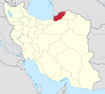
Golidagh District
Appearance
Golidagh District
Persian: بخش گلیداغ | |
|---|---|
| Coordinates: 37°39′11″N 55°54′56″E / 37.65306°N 55.91556°E[1] | |
| Country | |
| Province | Golestan |
| County | Maraveh Tappeh |
| Capital | Golidagh |
| Population (2016)[2] | |
| • Total | 28,728 |
| Time zone | UTC+3:30 (IRST) |
Golidagh District (Persian: بخش گلیداغ) is in Maraveh Tappeh County, Golestan province, Iran. Its capital is the city of Golidagh.
At the 2011 National Census, its population was 27,419 in 6,598 households.[3] At the latest census in 2016, the district had 28,728 inhabitants in 7,806 households.[2]
| Administrative Divisions | 2011[3] | 2016[2] | |
|---|---|---|---|
| Golidagh Rural District | 15,643 | 16,687 | |
| Shalami Rural District | 11,776 | 12,041 | |
| Golidagh (city)1 | |||
| Total | 27,419 | 28,728 | |
| 1Became a city after the 2016 census[4] | |||
References
- ^ OpenStreetMap contributors (14 October 2023). "Golidagh District (Maraveh Tappeh County)" (Map). OpenStreetMap. Retrieved 14 October 2023.
- ^ a b c "Census of the Islamic Republic of Iran, 1395 (2016)". AMAR (in Persian). The Statistical Center of Iran. p. 27. Archived from the original (Excel) on 29 March 2019. Retrieved 19 December 2022.
- ^ a b "Census of the Islamic Republic of Iran, 1390 (2011)" (Excel). Iran Data Portal (in Persian). The Statistical Center of Iran. p. 27. Retrieved 19 December 2022.
- ^ Fazli, Rahmani (1 November 2016). "The Minister of Interior agreed to convert Golidagh and Sadeqabad into cities". Golestanema (in Persian). Ministry of Interior. Archived from the original on 14 October 2023. Retrieved 14 October 2023.


