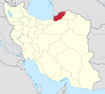
Minudasht County
Minudasht County
Persian: شهرستان مینودشت | |
|---|---|
County | |
 Location of Minudasht County in Golestan province | |
 Location of Golestan province in Iran | |
| Coordinates: 37°08′49″N 55°28′22″E / 37.14694°N 55.47278°E[1] | |
| Country | |
| Province | Golestan |
| Capital | Minudasht |
| Districts | Central, Kuhsarat |
| Population (2016)[2] | |
| • Total | 75,483 |
| Time zone | UTC+3:30 (IRST) |
| Minudasht County at GEOnet Names Server | |
Minudasht County (Persian: شهرستان مینودشت) is in Golestan province, Iran. Its capital is the city of Minudasht.
At the 2006 census, the county's population was 126,676, in 30,791 households.[3] The following census in 2011 counted 75,659 people in 20,852 households,[4] by which time Galikash District had been separated from the county in the establishment of Galikash County, and Kuhsarat Rural District had been separated from the Central District in the establishment of Kuhsarat District. At the 2016 census, the county's population was 75,483 in 22,719 households.[2]
Administrative divisions
The population history and structural changes of Minudasht County's administrative divisions over three consecutive censuses are shown in the following table. The latest census shows two districts, four rural districts, and one city.[2]
After the 2016 census, the villages of Alqajar[5] and Dowzeyn[6] were elevated to city status.
| Administrative Divisions | 2006[3] | 2011[4] | 2016[2] |
|---|---|---|---|
| Central District | 69,272 | 59,898 | 60,367 |
| Chehel Chay RD | 23,978 | 26,392 | 25,565 |
| Kuhsarat RD | 14,139 | ||
| Qaleh Qafeh RD | 5,172 | 5,028 | 4,717 |
| Alqajar (city)1 | |||
| Minudasht (city) | 25,983 | 28,478 | 30,085 |
| Galikash District2 | 57,404 | ||
| Nilkuh RD | 3,239 | ||
| Qaravolan RD | 16,202 | ||
| Yanqaq RD | 17,954 | ||
| Galikash (city) | 20,009 | ||
| Kuhsarat District | 15,745 | 15,116 | |
| Garu RD | 11,081 | 11,025 | |
| Sar Gol RD | 4,664 | 4,091 | |
| Dowzeyn (city)1 | |||
| Total | 126,676 | 75,659 | 75,483 |
| RD: Rural District 1Became a city after the 2016 census[5][6] 2Became a part of Galikash County | |||
References
- ^ OpenStreetMap contributors (14 October 2023). "Minudasht County" (Map). OpenStreetMap. Retrieved 14 October 2023.
- ^ a b c d "Census of the Islamic Republic of Iran, 1395 (2016)". AMAR (in Persian). The Statistical Center of Iran. p. 27. Archived from the original (Excel) on 29 March 2019. Retrieved 19 December 2022.
- ^ a b "Census of the Islamic Republic of Iran, 1385 (2006)". AMAR (in Persian). The Statistical Center of Iran. p. 27. Archived from the original (Excel) on 20 September 2011. Retrieved 25 September 2022.
- ^ a b "Census of the Islamic Republic of Iran, 1390 (2011)" (Excel). Iran Data Portal (in Persian). The Statistical Center of Iran. p. 27. Retrieved 19 December 2022.
- ^ a b "The approval letter regarding the conversion of Alqajar village of Chehel Chay Rural District..." RRK (in Persian). 22 September 2023. Archived from the original on 14 October 2023. Retrieved 14 October 2023.
- ^ a b "The mayor and former member of Minudasht city council became the first mayor of Dowzeyn". Golestanema (in Persian). 6 April 2018. Archived from the original on 14 October 2023. Retrieved 14 October 2023.

