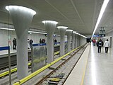
Wawrzyszew metro station
Appearance
 | |||||||||||
| General information | |||||||||||
| Coordinates | 52°17′11″N 20°56′22″E / 52.28639°N 20.93944°E | ||||||||||
| Owned by | Public Transport Authority | ||||||||||
| Platforms | 2 side platforms | ||||||||||
| Tracks | 2 | ||||||||||
| Connections | |||||||||||
| Construction | |||||||||||
| Structure type | Underground | ||||||||||
| Platform levels | 1 | ||||||||||
| Accessible | Yes | ||||||||||
| Architect | Andrzej M. Chołdzyński | ||||||||||
| Other information | |||||||||||
| Station code | A22 | ||||||||||
| Fare zone | 1 | ||||||||||
| History | |||||||||||
| Opened | 25 October 2008 | ||||||||||
| Services | |||||||||||
| |||||||||||
| |||||||||||
Metro Wawrzyszew, located at the corner of Kasprowicza and Lindego Street, became the 20th working station on Line M1 of the Warsaw Metro when it opened on 25 October 2008 as part of the extension from Słodowiec to Młociny.[1] It was designed by Polish architect Andrzej M. Chołdzyński.[2]
Gallery
-
Entrance to the station
-
Entrance to the station
-
Main platform
-
Interior detail
References
- ^ Schwandl, Robert. "UrbanRail.Net > Warszawa". Retrieved 1 September 2019.
- ^ "Andrzej Chołdzyński - architekt, właściciel, AMC Chołdzyński". www.propertydesign.pl (in Polish). Retrieved 2019-08-03.
External links
![]() Media related to Wawrzyszew metro station at Wikimedia Commons
Media related to Wawrzyszew metro station at Wikimedia Commons


