Hällekis
Hällekis | |
|---|---|
 Hällekis railway station | |
| Coordinates: 58°37′N 13°26′E / 58.617°N 13.433°E | |
| Country | Sweden |
| Province | Västergötland |
| County | Västra Götaland County |
| Municipality | Götene Municipality |
| Area | |
| • Total | 1.85 km2 (0.71 sq mi) |
| Population (31 December 2010)[1] | |
| • Total | 704 |
| • Density | 381/km2 (990/sq mi) |
| Time zone | UTC+1 (CET) |
| • Summer (DST) | UTC+2 (CEST) |
Hällekis (Swedish pronunciation: [ˈhɛ̂lːɛˌɕiːs])[2] is a locality situated in Götene Municipality, Västra Götaland County, Sweden. It had 704 inhabitants in 2010 compared to 904 in 1960, a decline due to the closure of the main employer.[1]
Location
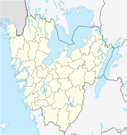
The village is situated on the coast of Lake Vänern to the north of Mount Kinnekulle with a 306 m (1,004 ft) ridge and large nature reserve. The nearest large towns are Mariestad and Lidköping, both about 20 miles (32 km) north-east and south-west respectively, with which it is connected by a light rail link.

History
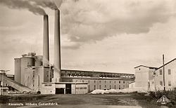
A mill was established in the village in the 18th century. With the availability of limestone nearby this was developed into a cement plant purchased in 1913 by Skånska Cement, the mother company of AB Skånska Cementgjuteriet, now known as Skanska. The factory closed in 1979.
On the outskirts of the village is the manor Hönsäter of which the most famous owner was Swedish military commander Harald Stake (1598-1677). The current main building dates back to 1667 but was remodelled in 1807. The manor was previously owned by Skånska Cement but is now privately owned.


References
- ^ a b c "Tätorternas landareal, folkmängd och invånare per km2 2005 och 2010" (in Swedish). Statistics Sweden. 14 December 2011. Archived from the original on 27 January 2012. Retrieved 10 January 2012.
- ^ Jöran Sahlgren; Gösta Bergman (1979). Svenska ortnamn med uttalsuppgifter (in Swedish). p. 12.
- ^ http://www.kinnekullehembygd.nu/hallekis_honsater.htm (in Swedish)
See also


