Green Quarter Fell
Appearance

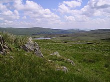
Green Quarter Fell is an upland area in the east of the English Lake District, near Kentmere village, Cumbria. It is the subject of a chapter of Wainwright's book The Outlying Fells of Lakeland.[1] Wainwright's walk is an anticlockwise circuit from Kentmere, reaching the summit of Hollow Moor at 1,394 feet (425 m) and a nameless summit at 1,370 feet (420 m) and making a detour to admire the tarn of Skeggles Water. He says that the walk offers: "... a perfectly-balanced and lovely view of upper Kentmere ... that cries aloud for a camera."
References
- ^ Wainwright, A. (1974). "Green Quarter Fell". The Outlying Fells of Lakeland. Kendal: Westmorland Gazette. pp. 14–17.
