
Carlyle, Montana
Carlyle is a ghost town in Wibaux County, Montana, United States, located approximately 1 to 1+1⁄2 miles west of the North Dakota border, sitting on a ranch, which incorporated the once agricultural town into grazing land. Some of the buildings once a part of the town are just foundations, however, a farmstead east of the town is still standing, with the school house, grain elevators and a couple of the homes inside the town. Southeast of the town of Carlyle is the cemetery. Carlyle had a population of 221 in the 1940s, with access to the North Pacific Railroad branch out of Beach, North Dakota.
External links
U.S. Geological Survey Geographic Names Information System: Carlyle, Montana
Municipalities and communities of Wibaux County, Montana, United States | ||
|---|---|---|
| Town | 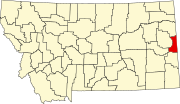 | |
| Unincorporated communities | ||
46°39′18″N 104°04′34″W / 46.65500°N 104.07611°W
This Montana state location article is a stub. You can help Wikipedia by expanding it. |