Scheibler (mountain)
Appearance
| Scheibler | |
|---|---|
 Scheibler (right), Darmstädter Hütte in front | |
| Highest point | |
| Elevation | 2,978 m (9,770 ft) |
| Prominence | 188 m (617 ft)[1][2] |
| Parent peak | Kuchenspitze |
| Isolation | 0.8 mi (1.3 km) |
| Coordinates | 47°03′31″N 10°13′19″E / 47.05861°N 10.22194°E |
| Geography | |
| Location | Tyrol, Austria |
| Parent range | Verwall Alps |
| Climbing | |
| Normal route | via Kuchenjöchli |
Scheibler is a 2,978 m (AA) high mountain in the Verwall Alps in the Austrian state Tyrol.
-
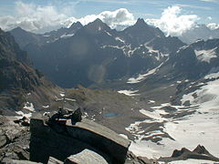
View from summit to the direction of Darmstädter Hütte
-
View from summit
There are directs ascents from two alpine club huts:
- From Darmstädter Hütte (2384 m, east of Scheibler) in two hours.[3]
- From Konstanzer Hütte (1688 m, north-west of Scheibler) in three hours.[4]
Both ascents meet at Kuchenjöchli, the 2,730-metre-high (8,960 ft) col between Scheibler and Kuchenspitze.[5]
References
- ^ Clem Clements, Jonathan de Ferranti, Eberhard Jurgalski, Mark Trengove: The 2500 m SUMMITS of AUSTRIA – 443 peaks of between 2500 m and 2999 m with at least 150 m of prominence, October 2011, accessed 2015-02-21.
- ^ AMAP: Österreichische Karte 1:50.000 (ÖK 50).
- ^ Deutscher Alpenverein: Darmstädter Hütte, 2384 m, accessed 2015-02-21.
- ^ Deutscher Alpenverein: Konstanzer Hütte, 1688 m, accessed 2015-02-21.
- ^ AMAP: Austrian Map 1:50.000


