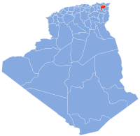
Oued Zenati
Appearance
Oued Zenati | |
|---|---|
Commune and town | |
 | |
 | |
| Country | |
| Province | Guelma Province |
| Population (2008) | |
| • Total | 32,870 |
| Time zone | UTC+1 (CET) |
Oued Zenati is a town and commune in Guelma Province, Algeria. According to the 1998 census it had a population of 27,254 which progressed to reach 55,000 in 2010.[1]
History
During the Numidian era, the region was highly cultivated and protected by military points spread all over the place, still present today.[2][3]
Geography
It is located 40 km (to the West) from Guelma, 110 km of Annaba and 70 km from Constantine. Oued Zenati is also the name of a river in the commune. The village has an agricultural vocation, very poor industrially.
Related people
- Taïeb Boulahrouf an Algerian politician, born in 1923
References
- ^ Statoids
- ^ Ch. de Vigneral. Ruines romaines de l'Algérie. Retrieved October 2, 2012.
- ^ Revue des deux mondes. Retrieved October 2, 2012.
36°19′N 7°10′E / 36.317°N 7.167°E

