
Makri, Evros
Makri
Μάκρη | |
|---|---|
Settlement | |
 Village harbour | |
 Makri | |
| Coordinates: 40°51′N 25°45′E / 40.850°N 25.750°E | |
| Country | Greece |
| Administrative region | East Macedonia and Thrace |
| Regional unit | Evros |
| Municipality | Alexandroupoli |
| Municipal unit | Alexandroupoli |
| Population (2011)[1] | |
| • Rural | 924 |
| • Community | 1,919 |
| Time zone | UTC+2 (EET) |
| • Summer (DST) | UTC+3 (EEST) |
| Vehicle registration | EB |
Makri (Greek: Μάκρη) is a village and a municipal district of the city of Alexandroupoli, Evros regional unit, Greece. In 2011 its population was 924 for the village, and 1,919 for the municipal district. It is situated on the Aegean Sea coast, 12 km west of downtown Alexandroupoli. Makri has an exit on the Egnatia Odos motorway, that passes north of the village.
Subdivisions
- Makri, pop. 924 in 2011
- Dikella, pop. 290
- Ennato, pop. 268
- Koimisi Theotokou, pop. 48
- Mesimvria, pop. 145
- Panorama, pop. 37
- Paralia Dikellon, pop. 102
- Plaka, pop. 105
Population
| Year | Village population | Population community |
|---|---|---|
| 1981 | - | 1,334 |
| 1991 | 738 | - |
| 2001 | 820 | 1,674 |
| 2011 | 924 | 1,919 |
History
Makri was ruled by the Ottoman Empire until the Balkan Wars of 1912 under the name Miri. It became a part of Bulgaria after 1912. In 1920 it became a part of Greece, and in 1941–1944 it was re-occupied by Bulgarian forces during the Axis Occupation of Greece.
Gallery
-
 View over Makri
 -
 View from nearby hill
 -
 Coastline
 -
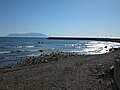
 View of Samothraki from Makri
 -
 Beach in summer time
 -
 Beach in spring
 -
 Cyclops Cave
 -
 Ruins of Byzantine church
 -
 Stream that runs through the village
 -
 Church exterior
 -
 Church interior


See also
External links
References
- ^ "Απογραφή Πληθυσμού - Κατοικιών 2011. ΜΟΝΙΜΟΣ Πληθυσμός" (in Greek). Hellenic Statistical Authority.