Jama, Kranj
Appearance
Jama | |
|---|---|
 | |
| Coordinates: 46°11′49.55″N 14°23′59.42″E / 46.1970972°N 14.3998389°E | |
| Country | |
| Traditional region | Upper Carniola |
| Statistical region | Upper Carniola |
| Municipality | Kranj |
| Area | |
| • Total | 1.19 km2 (0.46 sq mi) |
| Elevation | 365.2 m (1,198.2 ft) |
| Population (2002) | |
| • Total | 202 |
| [1] | |
Jama (pronounced [ˈjaːma]) is a village on the right bank of the Sava River in the Municipality of Kranj in the Upper Carniola region of Slovenia.[2] It lies northwest of Lake Trboje, the reservoir of the Mavčiče Hydroelectric Plant.[3]
Church

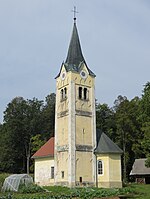
The village church is dedicated to Saint Leonard.[4]
References
- ^ Statistical Office of the Republic of Slovenia
- ^ Kranj municipal site
- ^ "Naselja: Jama". Geopedia.si. Geodetski inštitut Slovenije; Synergise, d. o. o. May 2007. Retrieved 22 August 2013.
- ^ Družina RC Church journal site
External links
- Jama at Geopedia.si
 Media related to Jama at Wikimedia Commons


