
Rozelle Bay
| Rozelle Bay | |
|---|---|
| Dllesse Error {{native name checker}}: parameter value is malformed (help) | |
 View of Rozelle Bay and the Anzac Bridge from Federal Park. | |
| Location | Inner West, New South Wales, Australia |
| Coordinates | 33°52′S 151°11′E / 33.867°S 151.183°E |
| Type | Bay |
| Part of | Sydney Harbour |
| Primary inflows | Johnstons Creek & Whites Creek |
| Settlements | Sydney |
Rozelle Bay is a bay located to the south of Glebe Island and the west of Blackwattle Bay, on Sydney Harbour.
The naming of the bay is derived from either the Rosella bird or the Rosella plant, with the latter being more likely, due to the other names in the area that have botanic origins.[1]
A light rail station on the Dulwich Hill Line is named after the bay.
Rozelle Bay is fed by Johnstons Creek[2] and Whites Creek.
The dockyard of the Sydney Heritage Fleet is located on the western shore of Rozelle Bay.
Gallery
-
 A cove of Rozelle Bay
 -
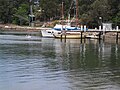
 View of Rozelle Bay Marina from Esther Abrahams Pavilion
 -
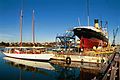 Sydney Heritage Fleet Dockyard


References
- ^ "Rozelle Bay". Geographical Names Register (GNR) of NSW. Geographical Names Board of New South Wales. Retrieved 3 August 2013.
- ^ "Johnstons Creek (gully)". Geographical Names Register (GNR) of NSW. Geographical Names Board of New South Wales. Retrieved 3 August 2013.
This article related to the geography of Sydney is a stub. You can help Wikipedia by expanding it. |