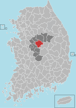
Goesan County
Appearance
Goesan
괴산군 | |
|---|---|
| Korean transcription(s) | |
| • Hangul | 괴산군 |
| • Hanja | 槐山郡 |
| • Revised Romanization | Goesan-gun |
| • McCune-Reischauer | Koesan-gun |
 No.3 National highway and overpassing Jungbu Inland Expressway | |
 Location in South Korea | |
| Country | |
| Region | Hoseo |
| Administrative divisions | 1 eup and 10 myeon |
| Area | |
| • Total | 842 km2 (325 sq mi) |
| Population | |
| • Total | 44,461 |
| • Density | 52.8/km2 (137/sq mi) |
| • Dialect | Chungcheong |
Goesan County (Goesan-gun) is a county in North Chungcheong Province, South Korea.
Tourist spot
- Sanmagi-yetgil
Sanmagi-yetgil is a 5 km (3.1 mi) road that extends from Sao-rang-maeul village (Oe-sa-ri, Chilseong-myeon, Goesan-gun, Chungbuk) to Sanmagi village in the mountains. It is a stroll path restored to resemble the traditional mountain road with a picturesque landscape.[1]
Twin towns – sister cities
Goesan is twinned with:
Domestic
- Gwanak-gu, Seoul
- Gangnam-gu, Seoul
- Guro-gu, Seoul
- Jung-gu, Incheon
- Anyang, Gyeonggi
- Ansan, Gyeonggi
- Uiwang, Gyeonggi
International
See also
References
- ^ JoongAng Daily http://news.joins.com/article/21920410
External links
Wikimedia Commons has media related to Goesan.
36°48′39″N 127°47′41″E / 36.8108333433°N 127.794722232°E


