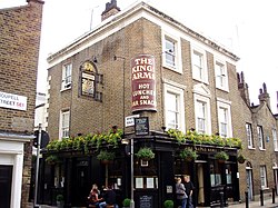
King's Arms, Waterloo
Tools
Actions
General
Print/export
Print/export
In other projects
Appearance
From Wikipedia, the free encyclopedia
This is an old revision of this page, as edited by Keith D (talk | contribs) at 22:38, 12 March 2019 (Use {{NHLE}} template). The present address (URL) is a permanent link to this revision, which may differ significantly from the current revision.
| King's Arms, Waterloo | |
|---|---|
 The King's Arms, Waterloo) | |
| General information | |
| Address | 25 Roupell Street, Waterloo |
| Town or city | London |
| Country | England |
| Coordinates | 51°30′16″N 0°06′33″W / 51.504401°N 0.109072°W / 51.504401; -0.109072 |
| Designations | |
Listed Building – Grade II | |
| Official name | King's Arms Public House |
| Designated | 27 August 1976 |
| Reference no. | 1064979 |
The King's Arms is a pub at 25 Roupell Street, Waterloo, London SE1.
It is a Grade II listed building, built in the early-mid 19th century.[1]
References
- ^ Historic England. "The King's Arms Public House (1064979)". National Heritage List for England. Retrieved 21 November 2016.
External links
- Official website
 Media related to King's Arms, Waterloo at Wikimedia Commons
This article about a listed building in the United Kingdom is a stub. You can help Wikipedia by expanding it. |
This article about a London building or structure is a stub. You can help Wikipedia by expanding it. |


