
Enerhodar
Enerhodar
Енергодар | |
|---|---|
| Enerhodar at night Enerhodar at night | |
 Flag  Coat of arms | |
 Enerhodar Location of Enerhodar in Ukraine | |
| Coordinates: 47°29′56″N 34°39′21″E / 47.49889°N 34.65583°E | |
| Country | Ukraine |
| Oblast | Zaporizhia |
| Founded | 1970 |
| City status | 1985 |
| Government | |
| • Mayor | Pavel Muzyika[1] |
| Area | |
• Total | 63.5 km2 (24.5 sq mi) |
| Elevation | 29 m (95 ft) |
| Population (2015) | |
• Total | 54,490 |
| • Density | 858/km2 (2,220/sq mi) |
| Area code | +380 6139 |
| Climate | Dfa |
| Website | www |
Enerhodar (Template:Lang-uk) is a city in north-west part of Zaporizhia Oblast, Ukraine. It is incorporated as a city of oblast significance. The population is 54,708 (2013 est.)[2].
Enerhodar is located on the left bank of Dnieper River near the Kakhovka Reservoir. The city was founded on June 12, 1970, for building and serving the Zaporizhia Nuclear Power Plant, the biggest nuclear power plant in Europe. Its major employers are the nuclear plant as well as a coal-fired thermal power station owned by Ukraine power company DTEK also located in the city.
Points of interest
Gallery
-
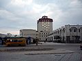 City Hall
 -
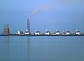
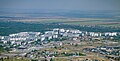 Enerhodar as seen from thermal power plant chimney
 -
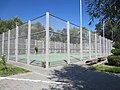 A tennis court in Enerhodar
 -
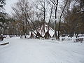 Victory Park in winter
 -
 Zaporizhya Nuclear Power Plant
 -


_%D1%81%D1%82%D0%B0%D0%BD%D1%86%D0%B8%D1%8F.jpg)
References
- ^ "The Mayor of Energodar has been wanted" (in Ukrainian). Ukrayinska Pravda. 26 July 2017. Retrieved 27 July 2017.
- ^ Чисельність наявного населення України [Actual population of Ukraine] (in Ukrainian). State Statistics Service of Ukraine. Archived from the original on 2014-02-02. Retrieved 21 January 2015.
External links
This article about a location in Zaporizhzhia Oblast is a stub. You can help Wikipedia by expanding it. |
Categories:
- Cities in Zaporizhia Oblast
- Populated places established in the Ukrainian Soviet Socialist Republic
- Populated places established in 1970
- Cities of regional significance in Ukraine
- Populated places on the Dnieper in Ukraine
- Company towns in Ukraine
- Populated places of Kakhovka Reservoir
- 1970 establishments in Ukraine
- Zaporizhzhia Oblast geography stubs