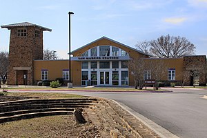
San Marcos station
Appearance
San Marcos, TX | |||||||||||||
|---|---|---|---|---|---|---|---|---|---|---|---|---|---|
 | |||||||||||||
| General information | |||||||||||||
| Location | 338 South Guadalupe Street San Marcos, TX 78666 United States | ||||||||||||
| Coordinates | 29°52′37″N 97°56′26″W / 29.87685°N 97.94045°W | ||||||||||||
| Owned by | CARTS | ||||||||||||
| Line(s) | Union Pacific Railroad | ||||||||||||
| Platforms | 1 side platform | ||||||||||||
| Tracks | 1 | ||||||||||||
| Other information | |||||||||||||
| Station code | Amtrak code: SMC | ||||||||||||
| History | |||||||||||||
| Opened | 2001 | ||||||||||||
| Passengers | |||||||||||||
| 2017 | 8,380[1] | ||||||||||||
| Services | |||||||||||||
| |||||||||||||
| |||||||||||||
San Marcos station is an intermodal transit center in San Marcos, Texas. It is served by Amtrak's Texas Eagle line as well as Capital Area Rural Transportation System and Greyhound Lines buses.
References
- ^ "Amtrak Fact Sheet, FY2017, State of Texas" (PDF). Amtrak. November 2017. Retrieved 16 December 2017.
External links
- San Marcos, TX – Amtrak
- San Marcos, TX – Station history at Great American Stations (Amtrak)
- San Marcos Amtrak Station (USA Rail Guide -- Train Web)
- Capital Area Rural Transportation System
- San Marcos, Texas (SMC) (Amtrak's Great American Stations)

