Yerkes (crater)
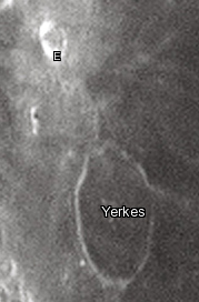
 LRO satellite image including its only satellite crater, Yerkes E | |
| Coordinates | 14°36′N 51°42′E / 14.6°N 51.7°E |
|---|---|
| Diameter | 36 km |
| Depth | None |
| Colongitude | 310° at sunrise |
| Eponym | Charles T. Yerkes |


Yerkes is a lunar impact crater near the western edge of Mare Crisium. It was named after American financier Charles Yerkes.[1] To the east of Yerkes is the crater Picard, and farther to the north is Peirce.
In the past the interior of this crater has been almost completely inundated by lava, leaving only a shallow remnant of a rim above the mare. The rim is widest on the western and southern portions, and barely existent to the east, forming a thin curve in the surface. A low ridge runs from the north rim to Yerkes E in the north-northwest. The floor has a similar albedo to the nearby mare, so the feature is not sharply distinguished from the surroundings.
Satellite craters
By convention these features are identified on lunar maps by placing the letter on the side of the crater midpoint that is closest to Yerkes.
| Yerkes | Latitude | Longitude | Diameter |
|---|---|---|---|
| E | 15.90° N | 50.67° E | 9.91 km |
| V | 15.24° N | 50.49° E | 3.7 km |
References
- ^ "Yerkes (crater)". Gazetteer of Planetary Nomenclature. USGS Astrogeology Research Program.
- Andersson, L. E.; Whitaker, E. A. (1982). NASA Catalogue of Lunar Nomenclature. NASA RP-1097.
{{cite book}}: Invalid|ref=harv(help) - Bussey, B.; Spudis, P. (2004). The Clementine Atlas of the Moon. New York: Cambridge University Press. ISBN 978-0-521-81528-4.
{{cite book}}: Invalid|ref=harv(help) - Cocks, Elijah E.; Cocks, Josiah C. (1995). Who's Who on the Moon: A Biographical Dictionary of Lunar Nomenclature. Tudor Publishers. ISBN 978-0-936389-27-1.
{{cite book}}: Invalid|ref=harv(help) - McDowell, Jonathan (July 15, 2007). "Lunar Nomenclature". Jonathan's Space Report. Retrieved 2007-10-24.
{{cite web}}: Invalid|ref=harv(help) - Menzel, D. H.; Minnaert, M.; Levin, B.; Dollfus, A.; Bell, B. (1971). "Report on Lunar Nomenclature by the Working Group of Commission 17 of the IAU". Space Science Reviews. 12 (2): 136–186. Bibcode:1971SSRv...12..136M. doi:10.1007/BF00171763.
{{cite journal}}: Invalid|ref=harv(help) - Moore, Patrick (2001). On the Moon. Sterling Publishing Co. ISBN 978-0-304-35469-6.
{{cite book}}: Invalid|ref=harv(help) - Price, Fred W. (1988). The Moon Observer's Handbook. Cambridge University Press. ISBN 978-0-521-33500-3.
{{cite book}}: Invalid|ref=harv(help) - Rükl, Antonín (1990). Atlas of the Moon. Kalmbach Books. ISBN 978-0-913135-17-4.
{{cite book}}: Invalid|ref=harv(help) - Webb, Rev. T. W. (1962). Celestial Objects for Common Telescopes (6th revised ed.). Dover. ISBN 978-0-486-20917-3.
{{cite book}}: Invalid|ref=harv(help) - Whitaker, Ewen A. (1999). Mapping and Naming the Moon. Cambridge University Press. ISBN 978-0-521-62248-6.
{{cite book}}: Invalid|ref=harv(help) - Wlasuk, Peter T. (2000). Observing the Moon. Springer. ISBN 978-1-85233-193-1.
{{cite book}}: Invalid|ref=harv(help)
