Ringland, Newport
| Ringland | |
|---|---|
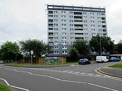
 Milton Court, Ringland in June 2016 | |
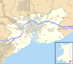
Location within Newport | |
| Population | 8,550 (2011 census)[1] |
| OS grid reference | ST352888 |
| Principal area | |
| Country | Wales |
| Sovereign state | United Kingdom |
| Post town | NEWPORT |
| Postcode district | NP19 9 |
| Postcode district | NP18 2 |
| Dialling code | 01633 Maindee exchange |
| Police | Gwent |
| Fire | South Wales |
| Ambulance | Welsh |
| UK Parliament | |
Ringland is both an electoral ward (district) and community (parish) of the city of Newport, South Wales.
The ward is bounded by Ringland Way to the east, the southern boundary of Llanwern High School to the south, Balfe Rd, Aberthaw Rd, Ringland Circle, Ringwood Avenue, across Chepstow Rd, Mountbatten close and behind Chiltern Close and Glanwern Grove to the west and the M4 motorway to the north.
Most of the houses and flats and shopping centre were built by the local council during the 1950s and 1960s, most of houses have generous sized gardens . Ringland is close to junction 24 of the motorway also 12 minutes drive from Newport Railway Station. Ringland has green spaces around the area including Ringland Wood run by the Woodland Trust.[2]
PLANS to transform Ringland into an "attractive, vibrant and modern" community have been submitted by Newport City Homes (NCH). The multi-million pound plans were submitted at the end of November 2017.[3]
Unemployment and crime levels in Ringland are above the national average since the decline of the Llanwern steelworks. It is home to the 5-star Celtic Manor Resort on the north side of the M4.[4] There were plans proposed in 2015 to invest in improvements to the shopping centre.[5]
In 2017 a permanent site for travellers or gypsies was created on Hartridge Farm Road. Archaeological remains dating from the Iron Age and Roman periods were found during the development.[6]
Local government
The area is governed by the Newport City Council.
References
- ^ "Newport ward 2011. Retrieved 2015-04-05".
- ^ "Wildlife Walks - Ringland Wood". www.gwentwildlife.org. Retrieved 1 December 2017.
- ^ "Multi-million pound plans for Newport have been submitted". South Wales Argus. Retrieved 2 December 2017.
- ^ Stephen Moss (24 September 2010). "'It's a them and us situation'". The Guardian. Retrieved 23 September 2017.
- ^ "'War zone' Ringland still plagued by anti-social behaviour say residents". South Wales Argus. 29 April 2015. Retrieved 23 September 2017.
- ^ Estel Farell-Roig (4 February 2017). "Ruins found at proposed Gipsy site in Ringland, Newport". South Wales Argus. Retrieved 23 September 2017.

