
Hrob
Hrob | |
|---|---|
Town | |
 Town square | |
 Flag  Coat of arms | |
 Hrob Location in the Czech Republic | |
| Coordinates: 50°39′32″N 13°43′28″E / 50.65889°N 13.72444°E | |
| Country | Czech Republic |
| Region | Ústí nad Labem |
| District | Teplice |
| First mentioned | 1282 |
| Government | |
| • Mayor | Jiří Fürst |
| Area | |
| • Total | 11.09 km2 (4.28 sq mi) |
| Elevation | 356 m (1,168 ft) |
| Population (2019-01-01[1]) | |
| • Total | 1,998 |
| • Density | 180/km2 (470/sq mi) |
| Time zone | UTC+1 (CET) |
| • Summer (DST) | UTC+2 (CEST) |
| Postal code | 417 04 |
| Website | www.mestohrob.cz |
Hrob (German: Klostergrab) is a town in the Teplice District in the Ústí nad Labem Region of the Czech Republic. It has a population of around 2,000. The first record of this town's existence dates back to 1282.
Gallery
-
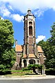 Evangelic church
 -
 Town hall


References
- ^ "Population of municipalities of the Czech republic". Czech Statistical Office. Retrieved 2019-04-30.
External links
 Media related to Hrob at Wikimedia Commons
| International | |
|---|---|
| National | |
This Ústí nad Labem Region location article is a stub. You can help Wikipedia by expanding it. |