
Groß Schacksdorf-Simmersdorf
Groß Schacksdorf-Simmersdorf | |
|---|---|
 Coat of arms | |
Location of Groß Schacksdorf-Simmersdorf within Spree-Neiße district  | |
 Groß Schacksdorf-Simmersdorf  Groß Schacksdorf-Simmersdorf | |
| Coordinates: 51°41′11″N 14°37′30″E / 51.68639°N 14.62500°E | |
| Country | Germany |
| State | Brandenburg |
| District | Spree-Neiße |
| Municipal assoc. | Döbern-Land |
| Government | |
| • Mayor | Wolfgang Katzula |
| Area | |
| • Total | 25.11 km2 (9.70 sq mi) |
| Elevation | 85 m (279 ft) |
| Population (2022-12-31)[1] | |
| • Total | 816 |
| • Density | 32/km2 (84/sq mi) |
| Time zone | UTC+01:00 (CET) |
| • Summer (DST) | UTC+02:00 (CEST) |
| Postal codes | 03149 |
| Dialling codes | 035695 |
| Vehicle registration | SPN |
Groß Schacksdorf-Simmersdorf (Lower Sorbian: Tšěšojce-Žymjerojce) is a municipality in the district of Spree-Neiße, in Brandenburg, Germany.
Demography
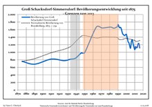
|
|
People
- Heinrich Sigismund von der Heyde (1703-1765), Prussian general
References
- ^ "Bevölkerungsentwicklung und Bevölkerungsstandim Land Brandenburg Dezember 2022" (PDF). Amt für Statistik Berlin-Brandenburg (in German). June 2023.
- ^ Detailed data sources are to be found in the Wikimedia Commons.Population Projection Brandenburg at Wikimedia Commons
This Brandenburg location article is a stub. You can help Wikipedia by expanding it. |