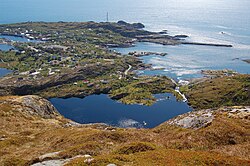
Sørvågen, Moskenes
Sørvågen | |
|---|---|
Village | |
 View of the western part of the village | |
Location in Nordland | |
| Coordinates: 67°53′23″N 13°00′59″E / 67.8897°N 13.0164°E | |
| Country | Norway |
| Region | Northern Norway |
| County | Nordland |
| District | Lofoten |
| Municipality | Moskenes |
| Area | |
• Total | 0.63 km2 (0.24 sq mi) |
| Elevation | 12 m (39 ft) |
| Population (2018)[1] | |
• Total | 440 |
| • Density | 698/km2 (1,810/sq mi) |
| Time zone | UTC+01:00 (CET) |
| • Summer (DST) | UTC+02:00 (CEST) |
| Post Code | 8392 Sørvågen |
Sørvågen is a fishing village in Moskenes Municipality in Nordland county, Norway. It is located on the island of Moskenesøya in the Lofoten archipelago. The village of Å lies just to the south. Moskenes Church is located just north of the village along European route E10.[3]
The 0.63-square-kilometre (160-acre) village has a population (2018) of 440 which gives the village a population density of 698 inhabitants per square kilometre (1,810/sq mi).[1]
Tourism

The village has several scenic and tourist attractions in and around the village. It contains a local department of the Norsk Telemuseum (Norwegian Telecom Museum) which reflects the local history of telegraphy.
In 1861, the island became part of the 170 kilometres (110 mi) long Lofoten telegraph line with a station in Sørvågen (which became the Sørvågen museum in 1914), being finally connected with Europe in 1867.
In 1906, a wireless telegraph system was installed in Sørvågen—the second in Europe after Italy—connecting Sørvågen with Røst.[4]
References
- ^ a b c Statistisk sentralbyrå (1 January 2018). "Urban settlements. Population and area, by municipality".
- ^ "Sørvågen, Moskenes (Nordland)". yr.no. Retrieved 9 December 2018.
- ^ Store norske leksikon. "Sørvågen" (in Norwegian). Retrieved 13 June 2012.
- ^ Filippo, H.; Pelzers, E. (2007). Noord Scandinavië: Lapland, Noordkaap, Lofoten, Spitsbergen (in Dutch). Uitgeverij Elmar. p. 150. ISBN 978-90-389-1745-0.
External links
 Media related to Sørvågen at Wikimedia Commons


