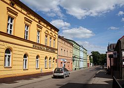
Brusy
Brusy | |
|---|---|
 | |
| Coordinates: 53°53′8″N 17°43′19″E / 53.88556°N 17.72194°E | |
| Country | |
| Voivodeship | Pomeranian |
| County | Chojnice |
| Gmina | Brusy |
| Area | |
| • Total | 5.1 km2 (2.0 sq mi) |
| Population (2006) | |
| • Total | 4,582 |
| • Density | 900/km2 (2,300/sq mi) |
| Postal code | 89-632 |
| Website | http://brusy.pl/ |
Brusy [ˈbrusɨ] (Kashubian: Brusë ;German: Bruß) is a town located in the Polish Pomeranian Voivodeship. It became a town in 1988.
History
Since the 19th century Brusy was an important center of the Kashub movement, although a fair amount of Kashubians from Brusy emigrated to Winona, Minnesota in the late 1900s.[1] In 2007, the ninth Congress of Kashubians was held here, and in 2012, the annual Kashubian Unity Day celebration was conducted here. A Kashubian Secondary School is also located in the town.
During World War II, the secret military organization Pomeranian Griffin (Gryf Pomorski) operated in the Brusy area under the leadership of Colonel Józef Wrycza, who was also a Roman Catholic priest. Brusy was also the location of the Nazis' Bruss sub-camp of the Stutthof concentration camp.
Notable people
- Jan Wyrowiński (born 1947) a Polish politician and Kashubian activist
- Stanisław Lamczyk (born 1957) a Polish politician, elected to the Sejm in 2005
- Piotr Piekarski (born 1964) a retired Polish 800 metres runner, participated in the 1992 Summer Olympics
See also
References
- ^ "First Settlement in Winona: 1859 – Bambenek.org". bambenek.org. Retrieved 2017-07-21.
External links
53°53′N 17°43′E / 53.883°N 17.717°E


