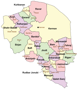
Kahnuj County
Appearance
Kahnuj County
شهرستان کهنوج | |
|---|---|
 Location in Kerman Province | |
 Location of Kerman Province in Iran | |
| Country | |
| Province | Kerman |
| Capital | Kahnuj |
| Bakhsh (Districts) | Central District |
| Government | |
| Area | |
| • Total | 2,109 km2 (814 sq mi) |
| Population (2016) | |
| • Total | 95,848 |
| Time zone | UTC+3:30 (IRST) |
| • Summer (DST) | UTC+4:30 (IRDT) |
Kahnuj County (Persian: شهرستان کهنوج) is a county in Kerman Province in Iran. The capital of the county is Kahnuj.[1] At the 2006 census, the county's population (including portions later split off to form Faryab County) was 102,269, in 21,780 families; excluding those portions, the population was 70,664, in 15,029 families.[2] The county has one district (bakhsh): the Central District. The county has one city: Kahnuj.
The local language of Kahnuj is a dialect of Jirofti. Jirofti and Kahnuji belong to the Garmsiri group, which is a continuum of closely related dialects extending from the Halilrud river valley in the north down to the Strait of Hormuz in the south.[3]
References
- ^ Gitashenasi Province Atlas of Iran
اطلس گیتاشناسی استانهای ایران Archived 2007-05-22 at the Wayback Machine - ^ "Census of the Islamic Republic of Iran, 1385 (2006)" (Excel). Statistical Center of Iran. Archived from the original on 2011-09-20.
- ^ Habib Borjian, “KERMAN xvi. LANGUAGES,” Encyclopædia Iranica, XVI/3, pp. 301-315, available online at http://www.iranicaonline.org/articles/kerman-16-languages

