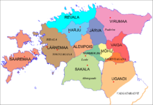
Harjumaa (ancient county)
Appearance
| Harria Harjumaa | |||||||
|---|---|---|---|---|---|---|---|
| County of Estonia | |||||||
| 1st century AD–1224 | |||||||
 Ancient Estonia until 1214 | |||||||
| Capital | Varbola | ||||||
| • Type | Council of Elders | ||||||
| History | |||||||
• Established | 1st century AD | ||||||
• Disestablished | 1224 | ||||||
| |||||||
Harjumaa, (Latin: Harria) [1](1200 hides), was an ancient county in what would now be Estonia. It corresponded roughly to the present territory of Rapla County.[citation needed]
Parishes
See also
- Danish Estonia
- Harju County
- Rapla County
- History of Estonia
- Livonian Crusade
- Rulers of Estonia
- St. George's Night Uprising
- Varbola Stronghold
References
- ^ Raun, Toivo (2001). Estonia and the Estonians. Hoover Press. p. 11. ISBN 0-8179-2852-9.
{{cite book}}: Cite has empty unknown parameter:|coauthors=(help)
