Dunback
This article needs additional citations for verification. (December 2019) |
Dunback
Waihemo | |
|---|---|
town | |
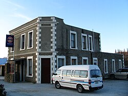
 The Highwayman Hotel at Dunback, built from local schist and limestone in 1864. | |
| Coordinates: 45°23′S 170°38′E / 45.383°S 170.633°E | |
| Country | New Zealand |
| Region | Otago |
| Territorial authority | Waitaki District |
| Population (2013) | |
| • Total | 705 (includes surrounds) |
| Time zone | UTC+12 (New Zealand Standard Time) |
| • Summer (DST) | UTC+13 (New Zealand Daylight Time) |
| Postcode | 9483 |
Dunback, formerly Waihemo, is a small town in the Otago region of New Zealand. It is located between Palmerston and Ranfurly on Highway 85. It has a population of about 200 people. Most of these people live in the rural areas near the town.
The New Zealand Ministry for Culture and Heritage gives a translation of "the finished stream" for Waihemo.[1]
The only remaining buildings now that still stand are the church, the Highwayman Hotel, the coronation hall and the Dunback school. All of these buildings are over 100 years old. There is also the domain which includes a cricket field, camping ground and bowling green. Locals and campers both enjoy the facilities that it has to offer. Along Murphy Street also stands the swing bridge which was built in the early 1900s for pupils to cross the Shag River for easier access to the school.
From 29 August 1885 until 1 January 1968, the town was the terminus of the Dunback Branch, a branch line railway that left the Main South Line in Palmerston. Nowadays, some of the old railway formation, a loading bank at the site of the station yard, and other railway relics can still be found around Dunback.
Demographics
The census area of Waihemo, which includes Dunback but is considerably larger, had a population of 705 at the 2013 New Zealand census, an increase of 30 people since the 2006 census. There were 372 males and 330 females. Figures have been rounded and do not add up to totals.[2] 95.0% were European/Pākehā, 5.4% were Māori, 1.4% were Pacific peoples and 0.5% were Asian.[3]
References
- ^ "1000 Māori place names". New Zealand Ministry for Culture and Heritage. 6 August 2019.
- ^ 2013 Census QuickStats about a place : Waihemo
- ^ 2013 Census QuickStats about a place (Cultural diversity) : Waihemo

