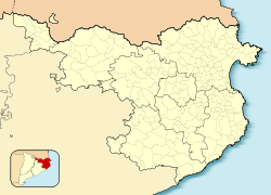
Anglès, Girona
Anglès | |
|---|---|
 Can Cendra gardens, in Anglès | |
| Coordinates: 41°57′N 2°39′E / 41.950°N 2.650°E | |
| Country | |
| Autonomous Community | |
| Province | Girona |
| Comarca | Selva |
| Government | |
| • Mayor | Astrid Victoria Desset (2015)[1] |
| Area | |
| • Total | 16.3 km2 (6.3 sq mi) |
| Elevation (AMSL) | 12 m (39 ft) |
| Population (2018)[3] | |
| • Total | 5,519 |
| • Density | 340/km2 (880/sq mi) |
| Postal code | 08001–17160 |
| Area code | +34 (Spain) + 972 (Girona) |
| Administrative Divisions | 6 |
| Website | www |
Anglès (Catalan pronunciation: [əŋˈɡlɛs]) is a Spanish municipality, in the comarca of Selva, in the province of Girona, Catalonia, Spain. It has an area of 16.30 km² and a population of 5,446 people (2008).
Notable people
- Remedios Varo Uranga, (Anglès, 1908 - Mexico City, 1963), Surrealist painter.
Villages
- Anglès, 5.005
- Cuc, 23
- La Farga, 6
- Les Mines del Sant Pare, 24
- Pla d'Amont, 102
- Pla d'Avall, 51
References
- ^ "Ajuntament d'Anglès". Generalitat of Catalonia. Retrieved 2015-11-13.
- ^ "El municipi en xifres: Anglès". Statistical Institute of Catalonia. Retrieved 2015-11-23.
- ^ Municipal Register of Spain 2018. National Statistics Institute.
External links
- Pàgina web de l'Ajuntament
- Government data pages (in Catalan)


