
Maçanet de Cabrenys
Maçanet de Cabrenys | |
|---|---|
 St. Martin's belltower | |
 Flag  Coat of arms | |
 | |
| Coordinates: 42°23′19″N 2°45′7″E / 42.38861°N 2.75194°E | |
| Country | Spain |
| Autonomous Community | Catalonia |
| Province | Girona |
| Comarca | Alt Empordà |
| Government | |
| • Mayor | Mercè Bosch i Romans (2015)[1] |
| Area | |
| • Total | 67.9 km2 (26.2 sq mi) |
| Elevation | 370 m (1,210 ft) |
| Population (2018)[3] | |
| • Total | 681 |
| • Density | 10/km2 (26/sq mi) |
| • Demonym | maçanetenc /maçanetenca |
| Website | ca |
Maçanet de Cabrenys is a municipality in the comarca of Alt Empordà, Girona, Catalonia, Spain. It also belongs to the subcomarca of Alta Garrotxa. It includes the villages of Arnera, Les Creus, Les Mines, Les Salines, Tapis, Els Vilars, and Oliveda. It is situated at the foot of the Eastern Pyrenees, with the Rivers Arnera and Frausa. It has numerous springs, which makes it attractive for tourism, the largest source of revenue, together with dryland farming and animal husbandry. It has a water bottling facility.
The center (370 m) is located in a valley between the two highest points of the municipal territory, the Puig de Les Salines (1331 m) and the roc de Frausa (1445 m).
History[edit]
Last century, near the river Arnera there were found neolitical axe, together with the menhir called La Pedra Dreta. Those findings show that the valley of the Arnera was populated from prehistoric periods. The first documented mention of the place appears in the precept of Louis the Pious in 814, in which it says that Céret limits south with villam quae dicitur Macanetum.
In 954 count Guifré II of Besalú gave to the monastery of Sant Pere of Camprodon the allodium of Tapis, to build the sanctuary of Les Salines. During the Medium Age it was fortified, and there are still remains of the wall with three covers of the 15th century. In 1440 they added de Cabrenys to Maçanet, because the village happens to belong to the barony of Cabrenys, a line of the lineage of the Rocabertí. In 1553 the black plague annihilates half of the population. In July 1675 lieutenant-general Le Bret,[4] with 1,500 men, plunders the village.
Economy[edit]
There are many sources, what joined to his climate, attracts a lot of tourism. That is the main source of economic income, together with construction, agriculture and livestock. There is a water bottling plant. There was textile industry, and factories that made cork caps. Now there are a lot of restaurants. There was a big factory of pipes. Now it remains a small workshop. Agriculture, livestock and forest industry have almost disappeared.
Places of interest[edit]
Church of Sant Martí[edit]
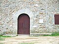
The church of Sant Martí, built in the 12th or 13th century, belongs to the late romanesque. It consists of a single rectangular nave covered by a vault in arc, and a semicircular apse covered by a vault in the form of an almond. The portal is formed by an eardrum cantilever with four arches and an arquivolta. The door, made of wood, has wrought iron details characteristic of that time.
-
 Façade of the church
 -
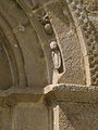 Details of the portal
 -
 Inside the church
 -
 Apse
Apse


Chapel of Sant Sebastià[edit]
It was built after the outbreak of plague at the end of the 16th century, by popular contributions. The present chapel is a reform made in the 18th century.
-
 Façade of the chapel
 -
 Inside the chapel
 -
 Apse
Apse


Sanctuary of Our Lady of Les Salines[edit]
It is situated almost in the summit of the mountain of this name. At 1,100 metres of height and 15 kilometres from the village. It was built in 1271 and reformed in the 18th century.
-
 Façade of the sanctuary
 -
 The door of the sanctuary
 -
 The source of the three jets, next to the sanctuary


Tapis[edit]

Tapis is a hamlet in the municipality of Maçanet de Cabrenys. It is cited for the first time in a document dated 954. In 2005 it had 25 inhabitants.
Church of Sant Briç[edit]
It is a building from the late 12th or early 13th century. From a single nave, two side chapels form transept. The apse, semicircular, with almond-shaped turn, opens onto the shed by means of a double arch. The slenderness of the turn, the proportions, the style and the structure of the capitals of the portal are elements that represented the final stage of Romanesque art.
-
 Church of Sant Briç
 -
 The bell tower
 -
 Inside the church
 -
 The door of the church


Mountains of Maçanet de Cabrenys[edit]

- Roc de Frausa.
- Roc del Comptador.
- Roc de la Campana.
- Castell de Bac Grillera.
- Puig d'Avall.
- Puig del Boixer.
- Puig Brosser.
- Puig de Calabuig.
- Puig del Coll dels Pins.
- El Cornell.
- Puig de la Creu.
- La Creu del Canonge.
- El Moixer.
- Puig de l'Evangeli.
- Puig del Faig.
- Puig Falcó.
- Puig Farner.
- Puig de la Guàrdia.
- Puig de la Jana.
- Roca Saquer.
- Puig de la Màquina.
- Puig de Milà.
- Puig de les Pedrisses.
- Puig de la Quera.
- Roc de la Sentinella.
- Roc del Pou.
- Rocacinta.
- Puig de les Roques.
- Puig de Rovirós.
- Puig del Solà de Sant Pere.
References[edit]
- ^ "Ajuntament de Maçanet de Cabrenys". Generalitat of Catalonia. Retrieved 2015-11-13.
- ^ "El municipi en xifres: Maçanet de Cabrenys". Statistical Institute of Catalonia. Retrieved 2015-11-23.
- ^ Municipal Register of Spain 2018. National Statistics Institute.
- ^ [1] David Steward: Assimilation and acculturation in seventeenth-century Europe: Roussillon and France 1659-1715
- Pere Roura i Sabà (1997). Maçanet de Cabrenys (Quaderns de la Revista de Girona, 71) (in Catalan). Girona, Diputació de Girona.
- Pere Roura i Sabà (1999). Maçanet de Cabrenys: història i natura (in Catalan). Girona, author.
- El meu país. Tots els pobles, viles i ciutats de Catalunya (in Catalan). Vol. 2. Barcelona, Edicions 62. 2005. ISBN 84-297-5569-1.
External links[edit]
- Website about Maçanet de Cabrenys, including articles, photos, and links
- Government data pages (in Catalan)
Places adjacent to Maçanet de Cabrenys | ||||||||||||||||
|---|---|---|---|---|---|---|---|---|---|---|---|---|---|---|---|---|
| ||||||||||||||||
| International | |
|---|---|
| Other | |