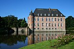
Gors Castle
Appearance
| Gors Castle | |
|---|---|
| Belgium | |
 | |
| Coordinates | 50°49′27″N 5°23′45″E / 50.8243°N 5.3958°E |
| Type | Castle |
Gors Castle (Template:Lang-nl) is a 19th-century country house, in Gors-Opleeuw in the municipality of Borgloon, province of Limburg, Belgium.
The original structure was a house of the 17th century, which was almost entirely rebuilt in the 1820s in a Neo-Classical style. The farm that was originally attached to the house was demolished in 1865 and rebuilt further away. Both house and farm have been protected monuments since 1986.
See also
External links
- Gors Castle, Kastelen in Limburg (in Dutch)


