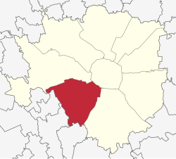
Zone 6 of Milan
Appearance
Zona 6 di Milano | |
|---|---|
Zona of Milan | |
 | |
 Location of Zone 6 of Milan | |
 Map of Zone 6 of Milan | |
| Country | |
| Region | Lombardy |
| Province | Milan (MI) |
| Comune | Milan |
| Area | |
| • Total | 7.06 sq mi (18.28 km2) |
| Population (2006) | |
| • Total | 164,487 |
| Time zone | UTC+1 (CET) |
| • Summer (DST) | UTC+2 (CEST) |
The Zone 6 of Milan (in Italian: Zona 6 di Milano) is one of the 9 administrative zones of Milan, Italy.[1] It corresponds to the south-western zone of the city.
Subdivision
The zone includes the following quarters: Arzaga, Barona, Boffalora, Cascina Bianca, Conchetta, Creta, Foppette, Giambellino-Lorenteggio, Lodovico il Moro, Moncucco, Porta Genova, Porta Ticinese, Ronchetto sul Naviglio, San Cristoforo, Sant'Ambrogio, Teramo, Villa Magentino and Villaggio dei Fiori.
Notable places
References
- ^ (in Italian) The 9 city councils of Milan (municipal website)
External links
![]() Media related to Municipio 6 (Milan) at Wikimedia Commons
Media related to Municipio 6 (Milan) at Wikimedia Commons
- (in Italian) Zone 6 of Milan (municipal website)
