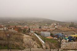
Castrillo del Val
This article needs additional citations for verification. (January 2020) |
Castrillo del Val | |
|---|---|
 View of Castrillo del Val, 2009 | |
| Country | Spain |
| Autonomous community | |
| Province | |
| Comarca | Alfoz de Burgos |
| Founded | 880-900 |
| Area | |
| • Total | 23 km2 (9 sq mi) |
| Elevation | 939 m (3,081 ft) |
| Population (2018)[1] | |
| • Total | 792 |
| • Density | 34/km2 (89/sq mi) |
| Time zone | UTC+1 (CET) |
| • Summer (DST) | UTC+2 (CEST) |
| Postal code | 09193 |
| Website | http://www.castrillodelval.es/ |
Castrillo del Val is a municipality located in the province of Burgos, Castile and León, Spain. It is in the valley of the River Arlanzón.
According to the 2004 census (INE), the municipality had a population of 515 inhabitants.
Main sights
- Abbey of San Pedro de Cardeña (9th-17th century)

This abbey was the burial place of El Cid, the 11th century warrior, his wife Jimena Díaz and, supposedly, his horse Babieca.[2] The remains were removed during the Napoleonic Wars when occupying troops ransacked tombs looking for treasure. El Cid and his wife were reburied in Burgos.
During the Spanish Civil War the monastery was used as a concentration camp.[3]
Since the 1940s the abbey has belonged to the Trappist order.
References
- ^ Municipal Register of Spain 2018. National Statistics Institute.
- ^ "Babieca". www.findagrave. Retrieved 2019-06-18.
- ^ "Terror en los campos de Franco". El País. 13 March 2019.
42°19′N 3°35′W / 42.317°N 3.583°W
