
Frías de Albarracín
Frías de Albarracín | |
|---|---|
 | |
 | |
| Coordinates: 40°20′N 1°37′W / 40.333°N 1.617°W | |
| Country | Spain |
| Autonomous community | Aragon |
| Province | Teruel |
| Comarca | Sierra de Albarracín Comarca |
| Municipality | Frías de Albarracín |
| Area | |
| • Total | 50.79 km2 (19.61 sq mi) |
| Elevation | 1,496 m (4,908 ft) |
| Population (2018)[1] | |
| • Total | 116 |
| • Density | 2.3/km2 (5.9/sq mi) |
| Time zone | UTC+1 (CET) |
| • Summer (DST) | UTC+2 (CEST) |
| Postal code | 44126 |
Frías de Albarracín is a municipality in the province of Teruel, Sierra de Albarracín Comarca, Aragon, Spain. The town is located in the Montes Universales area, Sistema Ibérico. According to the 2013 census (INE), the municipality has a population of 143 inhabitants.
The source of the Tagus is the Fuente de García, located within the Frías de Albarracín municipal term at almost 1600 m above sea level.[2]
-
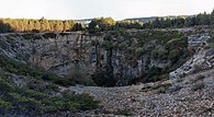 The chasm at Frías
 -
![Queseras,[3] containers for storing and preserving cheese, found at Frías castle.](//upload.wikimedia.org/wikipedia/commons/thumb/a/a1/Queseras_de_El_Castillo_%28Fr%C3%ADas_de_Albarrac%C3%ADn%2C_Teruel%29..JPG/195px-Queseras_de_El_Castillo_%28Fr%C3%ADas_de_Albarrac%C3%ADn%2C_Teruel%29..JPG)
-
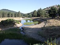 Tagus River source

![Queseras,[3] containers for storing and preserving cheese, found at Frías castle.](/wiki/File:Queseras_de_El_Castillo_(Fr%C3%ADas_de_Albarrac%C3%ADn,_Teruel)..JPG)

See also
References
- ^ Municipal Register of Spain 2018. National Statistics Institute.
- ^ Frías de Albarracín - Nacimiento del Rio Tajo, Teruel
- ^ Thorn Tree Forum - Cheesedish?
External links
 Media related to Frías de Albarracín at Wikimedia Commons
- Pictures of Frias town
| International | |
|---|---|
| National | |
| Other | |
This article about a location in Aragon, Spain, is a stub. You can help Wikipedia by expanding it. |