
Wolbromek
Wolbromek | |
|---|---|
Village | |
 Church of Saint Barbara | |
 Wolbromek Location of Wolbromek | |
| Coordinates: 50°56′00″N 16°10′00″E / 50.93333°N 16.16667°E | |
| Country | |
| Voivodeship | Lower Silesian |
| Powiat | Jawor |
| Gmina | Bolków |
| Highest elevation | 290 m (950 ft) |
| Population | 573 |
Wolbromek [vɔlˈbrɔmɛk] (German: Wolmsdorf) is a village in the administrative district of Gmina Bolków, within Jawor County, Lower Silesian Voivodeship, in south-western Poland.[1] Prior to 1945 it was in Germany.
It lies approximately 5 km (3 mi) east of Bolków, 13 km (8 mi) south of Jawor, and 65 km (40 mi) west of the regional capital Wrocław.
The village has a population of 573.
Gallery
-
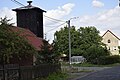 Fire station (left)
 -
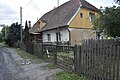 House
House -
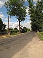 Road
Road
.jpg)
.jpg)
.jpg)
References
Wikimedia Commons has media related to Wolbromek.
| Town and seat |  | |
|---|---|---|
| Villages | ||
This Jawor County location article is a stub. You can help Wikipedia by expanding it. |