
Épila
Épila | |
|---|---|
municipality | |
 Panoramic view | |
 Seal | |
 Épila  Épila  Épila | |
| Coordinates: 41°36′00″N 1°16′59″W / 41.600°N 1.283°W | |
| Country | |
| Autonomous community | |
| Province | Zaragoza |
| Comarca | Valdejalón |
| Area | |
| • Total | 19,432 km2 (7,503 sq mi) |
| Elevation | 336 m (1,102 ft) |
| Population (2018)[1] | |
| • Total | 4,402 |
| Time zone | CET |
| • Summer (DST) | UTC+1 |
| Postal code | 50290 |
Épila is a municipality in the province of Zaragoza, Aragon, Spain. Its population in 2005 was approximately 4,100.
The Santuario de la Virgen de Rodanas is located in the Sierra de Nava Alta, west of Épila town. The road to the sanctuary from Épila is not paved.
Personalities
John I of Castile was born in Épila.
Photogallery
-
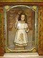 "El Cautivico" in Santa María la Mayor church
 -
 Romanesque chapel
 -
 Santa María la Mayor church


See also
References
This section is empty. You can help by adding to it. (January 2020) |
External links
![]() Media related to Épila at Wikimedia Commons
Media related to Épila at Wikimedia Commons
| International | |
|---|---|
| National | |
| Other | |
This article about a location in Aragon, Spain, is a stub. You can help Wikipedia by expanding it. |
- ^ Municipal Register of Spain 2018. National Statistics Institute.