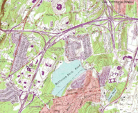
Batterson Park
| File:Batterson Park | |
|---|---|
 Batterson Park and surrounding area, 1990 | |
 | |
| Location | Farmington, CT |
| Coordinates | 41°42′55″N 72°47′25″W / 41.715198°N 72.790182°W |
| Opened | Circa 1928 |
| Operated by | City of Hartford |

Batterson Park is a public park owned by the City of Hartford, Connecticut, though located outside the city limits within the nearby towns of New Britain, CT, and Farmington. It is near Talcott Mountain State Park, and includes a large pond with a state-managed boat launch.[1] The pond was formerly used as reservoir managed by the City Water Department, and became a park sometime after 1928, when the water department turned over the disused land to the city. Parts of the land were sold or transferred for private development and highway construction in the time since, including 67 acres sold in 1988 to establish the Hartford Parks Trust Fund. Approximately 600 acres remain.[2]
Approximately 46% of the parkland owned by the City of Hartford is located outside of its jurisdiction, with the majority of that land comprising Batterson Park. The city is exploring options to create a regional partnership with neighboring towns to share maintenance costs. The town of Farmington has also approached the city to purchase the remaining parcels of Batterson Park, having purchased a portion in 2003.[2] In 2015, the city closed the park to the public due to the expense of maintenance and operation amidst larger budget troubles.[3]
In 2017, Hartford Mayor Luke Bronin proposed transferring land associated with Batterson Park to the city pension fund in 2017 in lieu of a payment of $5,000,000,[4] according to the Hartford Courant, although the land would easily sell for more than $100,000,000 if it was sold for residential use.[citation needed] In 2017, 86 acres of vacant residential-zoned land at 8261 FIENEMANN RD was transferred to the pension fund.[5] This same plot of city-owned land near the park was proposed for sale in 1997 to a developer, however that plan fell through.[6] The pension fund has not indicated whether it intends to maintain the land as a public park, or develop the lot for commercial and/or residential purposes.[4] As of August 2019[update], the remainder of the shuttered parkland (located on Batterson Park Road) remains under city ownership.[3]
References
- ^ Connecticut Agriculture Experiment Station: Batterson Park, Farmington (Updated 1 March 2013)
- ^ a b "Renewing a Historic Legacy: THE PARK SYSTEM of HARTFORD, CONNECTICUT" (PDF). TRUST FOR PUBLIC LAND, CONNECTICUT STATE OFFICE. October 2007. Archived from the original (PDF) on October 15, 2011. Retrieved June 2, 2016.
- ^ a b "Hartford-owned Batterson Park has been closed since 2015. A local conservancy wants to restore it to its former glory". The Hartford Courant. 15 August 2019. Retrieved 20 January 2018.
- ^ a b "MAYOR BRONIN'S 2017 BUDGET PROPOSAL". 18 April 2016. Retrieved 20 January 2018.
- ^ "8261 FIENEMANN RD". Town of Farmington Assessor's Office. 5 July 2017. Retrieved 20 January 2019.
- ^ "PROPOSAL TO SELL PART OF BATTERSON PARK DIES". The Hartford Courant. 29 April 1997. Retrieved 20 January 2020.
{{cite web}}: Cite has empty unknown parameter:|1=(help)
