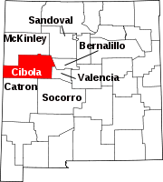
Casa Blanca, New Mexico
Appearance
Casa Blanca, New Mexico | |
|---|---|
| Coordinates: 35°02′44″N 107°28′17″W / 35.04556°N 107.47139°W | |
| Country | United States |
| State | New Mexico |
| County | Cibola |
| Elevation | 5,909 ft (1,801 m) |
| Time zone | UTC-7 (Mountain (MST)) |
| • Summer (DST) | UTC-6 (MDT) |
| ZIP code | 87007 |
| Area code | 505 |
| GNIS feature ID | 899561[1] |
Casa Blanca is an unincorporated community in Cibola County, New Mexico, United States.[1] Casa Blanca is located on New Mexico State Road 23 22.6 miles (36.4 km) east-southeast of Grants. It is part of the Paraje census-designated place. Casa Blanca has a post office with ZIP code 87007, which opened on September 22, 1905.[2][3]
References
- ^ a b "Casa Blanca". Geographic Names Information System. United States Geological Survey, United States Department of the Interior.
- ^ United States Postal Service (2012). "USPS - Look Up a ZIP Code". Retrieved 2012-02-15.
- ^ "Postmaster Finder - Post Offices by ZIP Code". United States Postal Service. Retrieved August 20, 2013.


