Neuville-au-Plain
Neuville-au-Plain | |
|---|---|
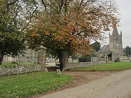
 The village with the church and the castle | |
| Coordinates: 49°25′42″N 1°19′43″W / 49.4283°N 1.3286°W | |
| Country | France |
| Region | Normandy |
| Department | Manche |
| Arrondissement | Cherbourg |
| Canton | Carentan |
| Intercommunality | La Baie du Cotentin |
| Government | |
| • Mayor (2008–2014) | André Pouthas |
Area 1 | 4.70 km2 (1.81 sq mi) |
| Population (2021)[1] | 86 |
| • Density | 18/km2 (47/sq mi) |
| Time zone | UTC+01:00 (CET) |
| • Summer (DST) | UTC+02:00 (CEST) |
| INSEE/Postal code | 50373 /50480 |
| Elevation | 2–36 m (6.6–118.1 ft) (avg. 10 m or 33 ft) |
| 1 French Land Register data, which excludes lakes, ponds, glaciers > 1 km2 (0.386 sq mi or 247 acres) and river estuaries. | |
Neuville-au-Plain is a commune in the Manche department in Normandy in north-western France.
World War 2
On June 6, 1944, Neuville-au-Plain was one objective of the 505th Infantry Regiment, 82nd Airborne Division of the United States Army in the invasion of Normandy. After capturing the commune early in the day, just 42 men of Company D/505 PIR, led by Lt. Turner B. Turnbull, were left to defend it. A much larger German force, consisting mainly of the 1058th Grenadier Regiment of the 91st Infantry Division, counterattacked and half of the defenders were killed or wounded in a heavy 8 hour battle. Eventually two of the American defenders, Sergeant Robert Niland and Corporal James Kelly, volunteered to remain behind. They were among wounded members of the 3rd platoon who held the German force off long enough for the rest to escape. Sergeant Niland was killed during this action[2]
See also
References
- ^ "Populations légales 2021" (in French). The National Institute of Statistics and Economic Studies. 28 December 2023.
- ^ Stephen E. Ambrose (2013). D-Day: June 6, 1944: The Climactic Battle of World War II. Simon and Schuster. pp. 316–317. ISBN 1439126305.


