
Kantakaupunki, Jyväskylä
Kantakaupunki | |
|---|---|
Ward of Jyväskylä | |
 Kantakaupunki seen from Harju | |
| Country | |
| Province | Western Finland |
| Region | Central Finland |
| Sub-region | Jyväskylä sub-region |
| City | Jyväskylä |
| Ward | Kantakaupunki |
| Population (2010) | |
| • Total | 25.149[1] |
| Time zone | UTC+2 (EET) |
| • Summer (DST) | UTC+3 (EEST) |
| Postal code | 40100 JYVÄSKYLÄ |
Kantakaupunki is a ward of Jyväskylä, Finland. Over 25.000 people live in Kantakaupunki. Keskusta, Puistola, Harju, Lutakko, Mattilanpelto, Mäki-Matti, Kukkumäki, Nisula, Taulumäki, Tourula and Mannila are districts of Kantakaupunki.
Gallery
-
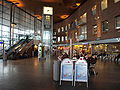
 Matkakeskus
 -
 Railway Station Interior
 -
 Kantakaupunki seen from Jyväsjärvi
 -
 Innova Tower
 -
 University, Seminaarinmäki Campus
 -
 Jyväskylä City Church and Church Park
 -
 Kauppakatu
 -
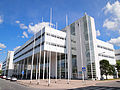 Agora Centre
 -
 Buses in front of the City Hall
 -
 Taulumäki Church
 -
 Vesilinna
 -
 Seminaarinmäki
 -
 Harju Stairs
 -
 A street in Lutakko
 -
 Viitaniemi neighborhood


References
- ^ "Tietoja Jyväskylästä suuralueittain". Tietoja Jyväskylästä suuralueittain. City of Jyväskylä. 7 July 2011. Archived from the original on 11 August 2018. Retrieved 26 February 2012.
External links
![]() Media related to Kantakaupunki, Jyväskylä at Wikimedia Commons
Media related to Kantakaupunki, Jyväskylä at Wikimedia Commons
62°13′22″N 25°46′39″E / 62.22278°N 25.77750°E
This Western Finland location article is a stub. You can help Wikipedia by expanding it. |